Google+ Mars Travel: 2013

Mars Science Laboratory's First Autonomous Drive

On Mars Science Laboratory (MSL) Curiosity's 376th sol on Mars (August 27 2013) the rover completed its first autonomous drive on Mars, when its computers chose a route and drove the rover for 10 meters (33 feet) through previously uncharted terrain before stopping. This feature analyzes photos taken by MSL to determine a safe path ahead, enabling the rover to safely and efficiently cover ground on its own, without guidance from human controllers. This technology can identify safe routes beyond what human controllers are able to assess; thus MSL can move further every drive. 

As Mark Maimore, MSL driver and mobility engineer, explained "Curiosity takes several sets of stereo pairs of images, and the rover's computer processes that information to map any geometric hazard or rough terrain. The rover considers all the paths it could take to get to the designated endpoint for the drive and chooses the best one." 

Below is a mosaic of many images taken immediately following that drive. Click the image to see it in high resolution.

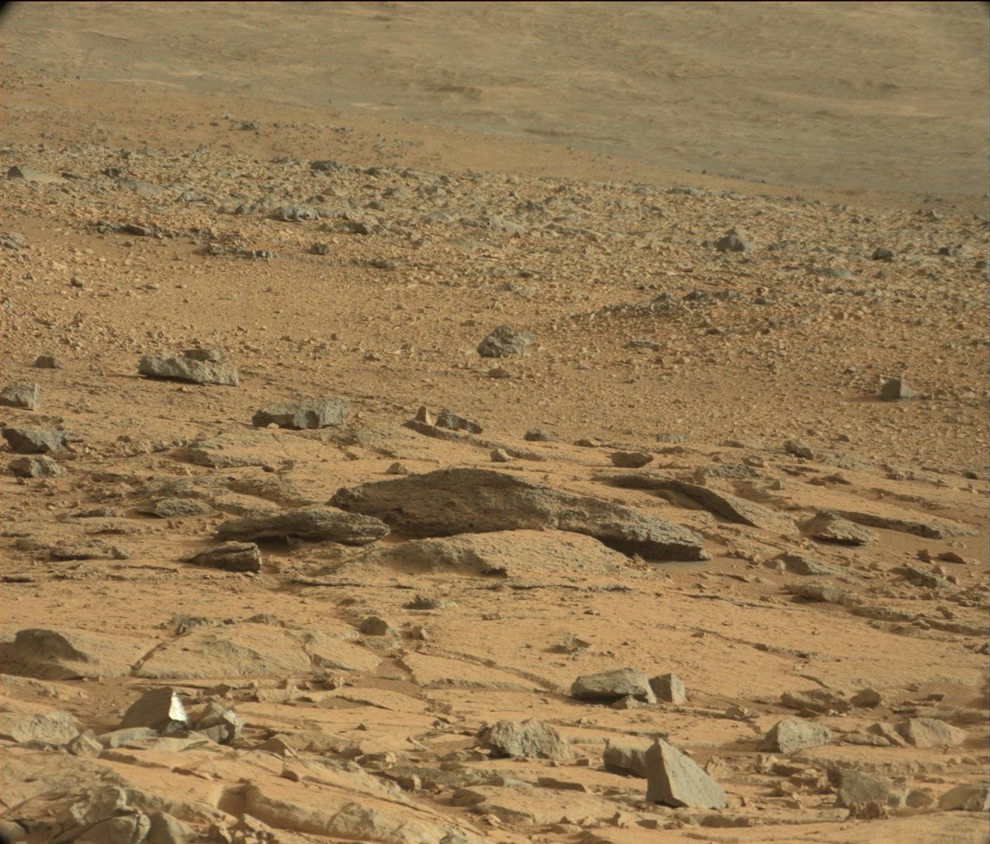
Mosaic of images taken by MSL on its 376th Sol on Mars. East is left and North is right (Southwest is center)
Source: NASA/JPL (Click Image for High Resolution Version)

The large mound in the left of the image is not Mount Sharp, but rather it is called Discovery Ridge and contains rocks no larger than .3 meters (1 foot) in diameter. The rise to the right of Discovery Ridge is wind-deposited material that has accumulated on the surface. This accumulation of material is approximately 4 meters (13 feet) long and lies approximately 10 meters (33 feet) from Curiosity

MSL Curiosity - One Year on Mars

One year ago today Mars Science Laboratory touched down on Mars. Since August 5th 2012 Curiosity has transmitted over 190 gigabits of data, sending more than 70,000 images back to Earth. Not only that, but Curiosity has driven over one mile and fired its laser 75,000 times at 2,000 different targets.

Click for larger image from NASA/JPL
With all that activity, many discoveries have been made, the most important of which have been identified in NASA's infographic on the right. Click the image to see the larger version from NASA.

While MSL's overall mission is to scale Mount Sharp at the center of Gale Crater and study it's various layers, the science team decided to examine nearby outcrops Glenelg and Yellow Knife which is where many of the discoveries to date have been made.

One of the most significant discoveries was that Mars once had an environment that was conducive to microbial life, but that Mars somehow lost most of it's atmosphere "through processes that occurred at the top of the atmosphere" (NASA)

The next NASA mission to Mars, Mars Atmosphere and Volatile Evolution (MAVEN), launches in November of this year and will attempt to determine what caused the atmosphere to bleed into space billions of years ago.

MSL Curiosity has also discovered evidence of an ancient streambed in the form of smooth, rounded sedimentary rocks, that likely rolled with a current for many miles. Bedrock, made up of millions of smaller compacted sediments has been discovered. This type of compaction is only known to occur in the presence of flowing water.

Further evidence that Mars once contained water has been found in the form of "gravels, streambed deposits, an unusual type of possibly volcanic rock, water-transported sand dunes, mudstones, and cracks filled with mineral veins." (NASA)

For a better understanding of MSL Curiosity's  one mile journey, take a look at the below  annotated image from NASA.

Click to see a larger version of this annotated image from NASA
MSL Curiosity's journey began one year ago today, and in that time it has traveled one mile and made numerous discoveries. The next year will see the rover complete its primary goal of  scaling Mount Sharp and provide even more insight into the past and current environment on Mars. Who knows what amazing discoveries will be made in the next year!

Kasei Valles and Echus Chasma

Most people know by now that Mars once contained a massive amount of water on its surface. It was during this period that Kasei Valles (shown below) was created by flood waters on Mars.

Kasei Valles
Image Credit: European Space Agency's Mars Express

One of the largest outflow channels on Mars, Kasei Valles measures 3000 km in length with a depth of 3 km, spanning a total of 1.55 million square kilometers.

Kasei Valles
Source: HiRISE
Within Kasei Valles lies the remains of Sharanov Crater, which had its southern rim collapsed by the floods that created the valley. This 100 km wide crater is depicted at top center in the below perspective view of Kasei Valles.

Sharanov Crater in Kasei Valles perspective view
Image Credit: European Space Agency's Mars Express

The floods that created Kasei Valles are thought to have emanated from Echus Chasma, which is imaged below. Echus Chasma spans 100km long and 10km wide and cuts into Lunae Planum, which is north of Valles Marineris.

Echus Chasma
Image Credit: European Space Agency's Mars Express
Echus Chasma was likely created when an impact or tectonic shift released water from a pressurized acquifer. Much like a dam breaking with enormous pressure, the force of the water ruptured the ground, leaving the incision we call Echus Chasma.

Echus Chasma
Image Credit: European Space Agency's Mars Express
The resulting release of water flooded the area directly north of Echus Chasma, thus creating Kasei Valles.

NASA's InSight Mission to Mars

In August 2012, around the same time that Mars Science Laboratory Curiosity landed in Gale Crater, NASA announced a new mission to Mars. This new mission is called InSight (Interior Exploration using Seismic Investigations, Geodesy and Heat Transport) and has a planned launch date of March 2016.

InSight will place a single lander on Mars in September 2016 with the capability of studying deep below the surface of the planet for a two year mission.

The lander will measure the seismology and internal temperature of planet Mars at varying levels. It will be able to determine whether Mars has a solid or liquid core and ascertain why Mars does not have tectonic plates similar to Earth. Understanding these facets of Mars as compared to Earth will provide insight into the formation of the other rocky planets in our inner solar system, including Earth, Venus, and Mercury.

An artist's rendition of proposed InSight Lander.
Source: NASA/JPL
InSight will be an international collaboration, with one of its four instruments coming from France's space agency, Centre National d'Etudes Spatiales (CNES) and another from the German Aerospace Center.  

Western Rim of Endeavour Crater Digital Terrain Model

The labeled image below is a digital terrain model (DTM) of the Western rim of Endeavour Crater overlain with a northward perspective from HiRISE and compositional data from the Compact Reconnaissance Imaging Spectrometer for Mars (CRISM). This is the area Mars Exploration Rover Opportunity has been investigating since 2011.

Click to see hires version from HiRISE

This image has been instrumental in planning Opportunity's movements and continuously developing mission. As indicated in the image above, orbital data has identified areas where clay (red), sulfate (green), and volcanic (blue) minerals could be present. Clays and sulfates are indicative of a watery past on Mars as they often only form in the presence of significant moisture.

Opportunity is currently around Cape York, but heading south in an attempt to discover more about the geology of Endeavour Crater.


1.3 Billion Pixel Mosaic from Mars Science Laboratory

Below is a panoramic mosaic of Mars compiled from almost 900 images taken by Mars Science Laboratory. Click on the image to see the interactive photo with over 1.3 billion pixels, then zoom in on any feature that interests you!

Click above to view the interactive 1.3 billion pixel image from MSL Curiosity!
Source: NASA/JPL

This images used to create this mosaic was taken while Curiosity was at Rocknest between October 5 and November 16 2013. The center of the image is directly south of the rover, while the right and left edges are north of it.

Definitely click on this image so that you can view all 1.3 billion magnificent pixels of Mars!

'Rat' on Mars

Recently a lot of people have been talking about a 'Rat' on Mars, so I thought I'd show you what all the fuss is about. To see this supposed 'rat' click on the first image for the high resolution version from NASA then zoom in on the upper left corner. See anything?

Click on the image for the High Resolution version from NASA then zoom in on the upper left corner. See anything?
What you might think is an animal is actually a psychological phenomena called pareidolia where your brain interprets vague objects as familiar shapes, or in this case, an animal.  This is an evolutionary trait in humans that once allowed us to easily identify predators on the horizon because we could easily identify their faces and features

In case you can't find the 'rat' in the photo above, I've included the zoomed in and circled version that Huffington Post compiled from UFO Sightings Daily below. UFO Sightings Daily was the first to report on the 'rat'.

While I believe this 'rat' on Mars is simply pareidolia, yet again on Mars, I leave it up to you to decide whether it is a 'rat' or simply your mind playing a trick on you. 

The Radiation Dilemma

Data from Mars Science Laboratory's Radiation Assessment Detector (RAD) is enabling scientists to accurately assess the level of radiation exposure experienced during a mission to Mars. Understanding the risks faced by astronauts on future manned missions to Mars will help scientists mitigate those risks. But what exactly are the risks?

Scientists have determined that the crew on a round-trip human mission to Mars would be exposed to 100 times the amount of radiation the average person experiences on an annual basis. The amount of radiation exposure faced by the crew could increase their risk of cancer by 5%, which is outside NASA's acceptable parameters. The risk increases if the astronauts land on Mars because they will not be shielded by the ship and Mars lacks a magnetic field like Earth's to shield people from radiation. The below graphic from NASA compares the level of radiation exposure from several experiences, including a round-trip mission to Mars.

Comparing Radiation of a Manned Missioon to Mars with Other Activities (NASA)

While the level of radiation exposure is important to understand and mitigate, there is no reason why it should be a show-stopper for space missions. Just as a soldier signs up for the military knowing he could get shot at, an astronaut knows they could die from a spacecraft malfunction or radiation exposure, among other things. These risks, while not inconsequential, are acceptable, as long as before the mission the crew understands and accepts the risks.

Not only that, but governments have no standing to prevent astronauts from embarking on potentially hazardous missions. There are numerous legal activities that increase a person's risk of cancer exponentially more than a trip to Mars. According to a study at Oxford, cigarette smoking causes a "25-fold increase in lung cancer risk in men smoking 25 cigarettes a day or more, compared to lifelong non-smokers,"  (Cancer Research UK) yet the government still allows people to smoke as many cigarettes as they want. Why then should astronauts be limited on how much risk they can take?

If governments refuse to allow astronauts to take the risks inherent in their job, then it will be dependent on private corporations unhindered by unnecessary regulations to begin human exploration of the solar system in earnest.

Counting Impact Craters on Mars

NASA has recently finished a study in which they determined the approximate number of asteroid and comet impacts on Mars every year. Using data collected by Mars Reconnaisance Orbiter (MRO) scientists have estimated there are 200 small craters formed every year on Mars as a result of asteroid and comet impacts. These craters measure at least 3.9 meters (12.8 feet) across.

MRO was able to image craters previously detected by itself and other Mars orbiters. Images of the same spots on Mars are taken at different times, thus if an older image does not show a crater, but a more recent one does, we know the impact occured before the most recent image, but after the one previous. This technique allows scientists to more accurately determine the age of craters on the surface.

Understanding the frequency of impacts is important to our understanding of Mars' past and allows scientists to more accurately determine the age of features on the planet. A feature or region with less impact craters is much younger than one with more craters because we know that overtime a feature on Mars will accumulate more impacts. The science will never be perfect, but can at least give us a better understanding of Mars and its development.

For example, scientists will be better able to determine the age of Hadley Crater based on the number of small craters within it. Just look at the image below and you will see that even within Hadley Crater there are multiple smaller craters.

Click to see the original high resolution image from Mars Express [See ESA article]

Previous estimates placed the number of yearly impacts on the Martian surface at 3 to 10 times the amount recently calculated. Those previous studies were done in the 1960s and 1970s and based off studies of lunar craters. MRO's HiRISE Principal Investigator Alfred McEwen says that this new study means "Mars now has the best-known current rate of cratering in the solar system," meaning that of all the bodies in the solar system, Mars is the one we are best able to determine the frequency of asteroid and comet impacts on.

Source:
Dwayne Brown, Guy Webster, Daniel Stolte. NASA Probe Counts Space Rock Impacts on Mars. 15 May 2013.NASA http://www.nasa.gov/home/hqnews/2013/may/HQ_13-142_Mars_MRO_Craters.html (accessed 15 May 2013) 

Mars Travel's Mars Photo of the Day - 15 Sept 2012

Russian Citizen Scientists Have Likely Discovered Mars 3 Lander

Recently, Russian citizen scientists claimed to have found the remnants of the failed Mars 3 Lander, which landed on Mars on December 2 1971, but had a communication failure after transmitting for only 14.5 seconds. This speculation led the Mars Reconnaissance Orbiter Team to further investigate the proposed sites on March 10 2013. Below you will see an image explaining what they investigated. To see the enlarged version from HiRISE simply click on the image below.


The candidiate descent module/retrorocket can be seen in the image above as well. It had a 4.5 meter chain attaching it to the lander, which is also visible. While the line is 4.8 meters, this difference could be explained if one assumes that it's momentum dragged it slightly across the surface. To best see this feature you will need to view the larger image from HiRISE by clicking on the image above.

The candidate site for the parachute can be seen below. I'm betting you can guess where it is even in this small version, but if you can't just click on it to see the larger high defintion image from HiRISE.


The parachute is the unusually bright spot right in the center of the image, which measures approximately 7.5 meters in diameter. Mars 3 had a paerachute that measured 11 meters in diameter if fully spread out, so a 7.5 meter diameter is consistent in that the parachute would most likely not be completely unfurled. In previous images of the area the parachute was likely covered in dust because the bright spot seen in the most recent image was not there. It's likely that the wind blew dust off the parachute recently, making its white color stand out against the backdrop of the Martian surface.

In 2007 HiRISE took an image of the the predicted landing site for the Mars-3 lander in Ptolemaeus Crater, but according to their website that image "contains 1.8 billion pixels of data, so about 2,500 typical computer screens would be needed to view the entire image at full resolution. Promising candidates for the hardware from Mars 3 were found only very recently." (HiRISE 2013)

The Russian citizen scientists were members of Russia's largest online community about Mars Science Laboratory Curiosity, started by Vitali Erogov. They crowdsourced the preliminary research that led to finding the candidate site for Mars 3. Vitali Erogov then compiled the below graphic of the candidate Mars 3 hardware pieces.

While all of these images match to what would be expected of the corresponding hardware, there is still some investigation to be done. Further analysis of the data, as well as current and future images, will help scientists to verify these findings and potentially determine what caused the communication failure in the first place. While the latter is a long-shot, you never know! For right now though, it looks like we have finally discovered Mars 3!

If nothing else, this just goes to show you the importance of citizen scientists. There is so much data out there it is impossible for scientists to look at it all, but when ordinary people take their free time to examine the data they can make extraordinary disoveries. I encourage every space enthusiast to join one of these citizen science programs by participating in NASA citizen science programs.

One of the biggest programs, whose participants have made numerous historic discoveries is Planet Hunters, which enlists people like you to help discover new planets. Planet Hunters has had and will continue to have enormous impact not only on the scientific community, but on all of mankind, as one day we must find a planet that we can survive on and colonize it, else we keep the fat eof our entire species tied to that of a single planet or solar system.

So if you have some free time, join Planet Hunters and help humanity live on forever!

Mars Solar Conjunction Limits Communication From Earth, Mars

Due to a Mars Solar Conjunction, an alignment where the Sun blocks the line of sight between Earth and Mars, there will be limited communication with the rovers or orbiters on Mars until May 1 2013.This particular planetary alignment began on April 4. Because of the interference from the Sun, any communications risks getting garbled on its way from Earth to Mars or vice versa. If we were to send a command to a rover and it became scrambled the rover could easily be put in danger, so scientists generally send a large number of sequenced, toned-back commands before Mars Solar Conjunctions.

Diagram Depicting a Mars Solar Conjunction

Both Mars Science Laboratory (MSL) Curiosity and Mars Exploration Rover Opportunity are prohibited from driving, so instead they are tasked with studying their surroundings. The rovers will continue sending brief tones to Earth so that the science teams can assess their safety. NASA's orbiting Mars Odyssey, Mars Reconnaissance Orbiter, and the ESA's Mars Express Orbiter will continue to make observations of the planet, based on pre-input directions, but the latter two will most likely not transmit any data back to Earth until May 1 2013. Mars Odyssey will transmit some data back to Earth over the next month.

This is Curiosity's first time going through a Mars Solar Conjunction, which occurs every two years, but Opportunity has been through a handful of them, so there isn't much to be concerned about. Be sure to check back in on them once communications are reestablished!


Examining Images of Aureum Chaos for Change

The primary source of erosion on Mars today is the wind. Scientists try to learn more about the wind and the changes it makes to the surface by studying images of Mars. To find these changes we often have to examine two pictures from a location taken at different times. This is true of the below photos taken of Aureum Chaos.

Acquired two Mars years ago. Source: HiRISE

Source: HiRISE

Although the above images are not exact overlays of one another, one can still pinpoint areas present in both images. Once done scientists can determine if there have been any changes or movements to material in the area. Although a preliminary look shows no changes in the past two years, a more fine-tuned examination will likely reveal minor changes.

Studying changes to the terrain allows scientists to assess the real affect of the wind on the environment. Knowing this will help us to know what we might see on the ground and what to watch out for on future prolonged missions to the surface. Imagine if you are living on Mars and you wake up one day to see rocks moved and sand displaced you might be disconcerted, but if you know about the wind you won't worry as much. Understanding how much effect the wind has on the surface also ensures that scientists take frequent images of landing areas because they know what might be a smooth area one week could be rocky terrain the next.

Studying images like the ones above ensures scientists learn the most they can about the wind on Mars and its effects on the environment.

Sampling the Surface of Mars

Thanks to Mars Science Laboratory (MSL) Curiosity, we know that Mars is a familar grey just below the surface. The image below shows the area where MSL first used its rock abrasion tool to remove a surface layer of dust, exposing the underlying grey rock, named Ekwir_1.

Source: NASA (Click image to see larger, captioned original)

MSL then drilled into a separate rock, dubbed John Klein, on 8 Feb 2013, or Sol 182 of its operation on Mars. This was the first sample drilling conducted by MSL on Mars. The below hole measures 6.4 centimeters (2.5 inches) deep.

Source: NASA (Click image to see larger original)

After drilling, MSL transfeered a powdered sample of the rock from the drill into its sample collection scoop. The below image, taken on 20 Feb 2013, shows the powdered rock sample obtained from the drilling. This is the first ever interior sample of a rock taken on another planet. Currently, MSL is examining small portions of the sample through the its Chemistry and Mineralogy (CheMin) instrument and Sample Analysis at Mars (SAM) instrument. The samples were processed into both analysis intruments on the 22nd and 23rd of February, but due to a computer issue the samples have yet to be analyzed.


Source: NASA (Click image to see larger, captioned original)


John Klein is a veiny, fined grained sedimentary rock. It was chosen as the first location for drilling because it likely holds evidence of past wet conditions on Mars. MSL's analysis of the powdered sample will give us insight to the past environment on Mars.

On 28 February MSL's science team switched to a redundant onboard computer in response to a memory failure on the original, previously active computer. The transition resulted in the rover going into safe mode until 4 March, at which point it entered active status again. Despite this, the rover won't become fully operational for another few days.

Because of the computer issue MSL hasn't been able to analyze the powdered rock sample, but once systems come back on line we should see results within the subsequent few days. What will we find out about the past environment of Mars? Will we find out that Mars was or habitable? We can only guess for now, but within a week we should have the results back!


Americans Anticipate Manned Mission to Mars Within 20 Years

According to a poll dubbed Mars Generation, Approximately 71% of Americans are excited for and anticipate a manned mission to Mars in the next 20 years, with more than half of American's feeling NASA should "play a strong role" in assisting a commercial company, or head up a mission themselves.

In the same poll, conducted by Phillips & Company and sponsored by The Boeing Corporation and Explore Mars, a majority of respondents incorrectly answered that they felt NASA's budget represented 2.5% of the federal budget (~$88.5 Billion). When presented with the reality that NASA's Fiscal Year 2013 budget sits at about .5% ($17.7 Billion) of the federal budget, 75% of those polled felt the Agency's funding should be doubled to 1% ($35.4 Billion) of the federal budget, with the express purpose of funding a manned mission to Mars.

Chris Carberry, Executive Director of Explore Mars, the non-profit that sponsored the Mars Generation poll proclaimed, “Despite difficult economic times, the American people are still inspired by space exploration and are committed to human exploration of Mars. This is a wake up call to our leaders that Americans are still explorers.” The poll showed this adventurous spirit is exemplified in the top three reasons Americans support a manned mission to Mars: to support a greater understanding of the planet, to search for signs of life on Mars, and to maintain American leadership in space. 73% feel a major hurdle to a manned mission to mars is affordability and 67% feel politics will be a large impediment to success.

An executive committee member of The Mars Initiativea non-profit 501(c)(3) organization unaffiliated with this study,  interpreted these results as a sign of the American people's continued fascination with space: "Americans want space exploration to be more of a national priority. This poll should serve as a message for America's leaders that their citizens want to see more of a commitment to the space industry, not less." A full report on the poll's findings will be released on 4 March 2013.


Let's hope America's leaders take note of this poll, but in the meantime, I encourage you to keep following news about Mars and sharing it with people you know. The more people we have that support missions to Mars, the more likely it will become a national, or even global priority.

One easy way you are guaranteed to support the first manned mission to Mars is by joining The Mars Initiative, so I encourage you to take a look!

Nearly 90% of Mars Mapped by Mars Express

Earlier this month the the ESA made an astounding revelation: their Mars Express Orbiter's High Resolution Stereo Camera (HRSC) has successfully mapped nearly 90% of Mars' surface! Thus far 87.8% of the surface has been imaged, with 61.5% being imaged at a resolution of 20m per pixel or better. Mars Express was launched just ten years ago this June, making this feat even more remarkable.

The below map is a mosaic of 2702 individual images showing the entire Martian globe. The latest image was taken on the orbiter's 10,821st orbit of Mars, which took place on 20 June 2012 orbit. This map does not include areas that were particularly affected by dust and/or atmospheric distortions; these areas are shown in black.

Click to see the ESA's caption for this photo. From there you can download the high resolution version.

The slight change in color tones is primarily due to changes in Mars Express' solar elevation, but can also be attributed to variations in dust content in different parts of the atmosphere. I encourage you to go to the ESA's website (just click the above image) and download their high resolution version! Once you do that, try and find some of the more prominent features on Mars, like Olympus Mons (top left) and the Tharsis Trio (below Olympus Mons and to the right), or Valles Marineris (further right of the Tharsis Trio).

Cone-Shaped Hill on Mars

In the South Polar Region of Mars' Promethei Lingula there is an unusual cone shaped hill, measuring about 20-30 meters high. The white streaks are areas where carbon dioxide ice has not yet thawed. The unusual shape of this hill can likely be attributed to large scale erosion. Scientists still aren't sure why the area wasn't eroded evenly, but as they study more images of features like this they will gain a better understanding of the environment that created them.

Click to see HiRISE's original high resolution version. [See HiRISE caption]


One possible way this cone-shaped hill was created would have occurred long ago, when it once rained on Mars. A meteor could have hit the area, creating a crater, which would eventually developed a central uplift. After millions of years of rainfall the central uplift would have been smoothed out to what we see above, as the water flowed down its slopes. Over millions of years the distinguishing characteristics of the surrounding crater would have been washed away by the rain, blending it into the regional terrain. That's just a theory and an example of the fact that we may never know what caused this feature on Mars to develop.


The Mars Initiative

The world is full of people that want to see humans on Mars. Until now the average person had no means to support such a difficult and expensive mission. The Mars Initiative has changed that!


The Mars Initiative is a non-profit organization that seeks to gain the support of one million people for a human mission to Mars. If a million (or more) people were donating just one dollar every month, The Mars Initiative would raise, at a minimum, $12 million dollars a year. All of this money would go to the agency or corporation that launches the first manned mission to Mars. The concept is very similar to the Google Lunar X Prize, except the amount is not a fixed, rather it depends on the amount of donations received from the public. The fund will continue growing until such time as the first manned Mars mission leaves Earth's surface.

The Mars Initiative is entirely transparent. All donations go to a bank account that will remain untouched until the first manned mission to Mars lifts off. Every bank statement is uploaded monthly to The Mars Initiative's website, allowing the public to keep track of all donations.

One of the greatest aspects of The Mars Initiative is that it is entirely volunteer-based. Whether it be website development, public relations, or even legal, everything is done on a volunteer basis. What's more, any person is welcome to volunteer and grow The Mars Initiative. In the future there will be a list of tasks that the organization needs to accomplish and people will be able to check out that task. This novel method will let people choose the tasks they are best suited to complete, ensuring that people of any background can  contribute to The Mars Initiative and give everyone a chance to be a part of history.


The Mars Initiative's transparent fundraising and entirely volunteer-based approach will produce a large number of supporters throughout the world and guarantee that it accomplishes its goal of securing at least one million people for a human mission to Mars.

The Mars Initiative's founder and President is Mina Mukhar, a distinguished financial advisor with an MBA and Masters of Science in Accounting and Information Systems from University of Texas - Dallas. [See The Mars Initiative's entire leadership team]

I'll be posting regular updates about The Mars Initiative here, so keep checking back in!

Colorful Crater on Mars

Check out these colorful images of a young, well preserved crater on Mars! When this 5km (3.1 mi) diameter crater was created it exposed a whole litany of minerals that may otherwise have been hidden under millions of years of dust build up and layered deposits.

The green (pictured bottom left) along the crater's south rim is representative of minerals like olivine and pyroxene, typically found in lava and underground magma flows. The yellow seen at the top of the image could be indicative of material changed by water, however, scientists also say it could just be a coating of dust. If the yellow material is just dust that could be indicative of a north blowing wind, which pushed the dust up against the south-facing north wall of the crater.

Click on the photo on the right to see the high resolution version from HiRISE. Click the bottom left photo to see the HiRISE caption


Birds-Eye View of MSL Curiosity

Take a look at HiRISE's birds-eye view of MSL Curiosity, taken on the 157th sol of it's mission in Gale Crater. In this image you can see the rover itself, as well as tracks left from MSL's movement across the Martian terrain (this is especially true if you click on the image). The bright white/blue dots on the right shows the the area that was directly below MSL's Sky Crane rockets. Because of wind and other factors, the earliest tracks from MSL have begun to fade, but fortunately they can still be made out in the larger high resolution version (just click the image below to see it)! 

Source: HiRISE

This image is quite significant because it is the first color image showing MSL's tracks from orbit. It is oftentimes these images that provide us perspective because they show us the impact we are having on this pristine planet. Every rover we send to Mars is breaking new ground, every image shows a never before seen world, every soil analysis enhances our understanding of the solar system and provides context for our place in the universe. 

McLaughlin Crater - A Once Lively Lake?

McLaughlin Crater on Mars may have once been home to a massive lake! That's according to new spectrometer date from NASA's Mars Reconnaissance Orbiter (MRO).

McLaughlin is a 92 kilometers (57 miles) in diameter and 2.2 kilometers (1.4 miles) deep. The crater's extreme depth tapped into typically unexposed underground channels of water, which then filled the crater.

Click to see larger, annotated, and captioned version from NASA
MRO discovered clays and carbonates, which only form in the presence of water, on the floor of McLaughlin Crater. We know small underground channels fed this massive lake because there is no evidence of any large outflow channels leading into the crater. Additionally, small channels within the crater end at a certain point on the crater wall, which was likely the level of of the lake.

This new discovery of clays and carbonates in McLaughlin Crater has added even more hope that life once, or maybe still does, exist on Mars. The presence of carbonates in particular indicates that the lake likely had low-acid content because carbonates generally do not remain preserved in high-acid environments. Life as we know is most likely to exist in low-acid environments, so having this knowledge makes scientists think this crater and the underground tributary channels may be the ideal place to search for evidence of past and/or present life.


First Use of MSL's Dust Removal Tool

The below image shows the first patch of rock on Mars that Mars Science Laboratory's (MSL) Dust Removal Tool (DRT) brushed off. This dust removal took place on the 150th Martian sol of MSL's mission (6 Jan 2013) on a rock named Ekwir_1. The cleared patch of rock is 47x62mm (1.85x2.44in).

Area cleared of dust on Ekwir_1 rock by Dust Removal Tool
Source: NASA/JPL (Click to see larger official image from NASA)
MSL's Dust Removal Tool is similar to Mars Exploration Rovers Opportunity and Spirit's Rock Abrasion Tool (RAT), except that MSL's tool is primarily used for dusting surfaces off, while the RAT is often used to grind/drill into the top layer off a rock, exposing the unweathered material beneath for further examination.

If you want to know what the DRT looks like, just take a look at the following image from NASA!

MSL's Dust Removal Tool (DRT) from two angles
Source: NASA/JPL
These tools to remove dust are essential to any Mars rover's mission because essentially the entire surface is covered by a fine layer of dust. There could be incredible minerals or even evidence of life below the dust, but we'd never discover it if we don't remove that surface layer. As MSL continues on toward Mount Sharp it will undoubtedly keep using its DRT to expose the beauty of Mars that lies only millimeters beneath the surface. 

When it does I'll be sure to post those images too!