Google+ Mars Travel: June 2012

Mars Photo of the Day - 29 Jun 2012

Today's Image of Mars shows colorful layers in Nili Fossae that are thought to contain carbonates. On Earth carbonates are commonly formed by marine organisms! Could it be that there was once life in the waters of Mars? Maybe!

Despite this tantalizing possibility, most scientsts are more reserved in their assessments, believing instead that there is some currently unknown reason why the carbonates formed on Mars. However, the scientists do say that water was most likely involved in the formation of the carbonates.

One day we may send a mission to this area in Nili Fossae, but for now we can only speculate and wonder about the origins of the carbonates. Clicking on this image will take you to the original high resolution image from HiRISE. [See their caption for the image]


Entry, Descent & Landing for Mars Science Laboratory Curiosity - 7 Minutes of Terror

When Mars Science Laboratory (MSL) Curiosity performs its entry, descent and landing (EDL) sequence, it will be 7 minutes of terror. 

"EDL is referred to as the 7 minutes of terror because we've got literally 7 minutes to get from the top of the atmosphere to the surface of Mars. Going from 13000 miles per hour to 0, in perfect sequence, perfect choreography, perfect timing... If any one things doesn't work just right it's game over" - Tim Revellini, EDL Engineer for MSL Curiosity.

Below is the NASA/JPL video about landing Curiosity on Mars. Touchdown is anticipated at 0131 ET on 6 Aug 2012!


Mars Photo of the Day - 25 June 2012

Today's Image of Mars shows what happened in Deuteronilus Mensae when ice quickly disappeared from the surface. The image below is of glaciers that once contained an abundance of ice, but when the climate changed, much of the ice on and near the surface disappeared into the atmosphere.

When the ice sublimated into the atmosphere it caused overlying terrain to collapse in on itself, creating the sharp, irregular features you see below. If we can determine when the features changed then that could tell us exactly when the climate on Mars went through a transition. If we know when the transition occurred we can make better guesses as to the reason behind the climate change. Perhaps an enormous asteroid collided with the planet, or maybe the rotational axis changed; there are unlimited possibilities, but knowing the time frame can help us narrow them down.

Clicking on this image will take you to the original high resolution HiRISE image.
[See their caption for the image]

Mars Photo of the Day - 19 June 2012

Today's Image of Mars shows bright material on the floor of a trough in Noctis Labyrinthus, which lies on the far western edge of Hellas Basin, just east of the Tharsis Volcanoes. What is this bright material, and under what circumstances did it form?

Examination of this bright material by Mars Reconnaissance Orbiter's CRISM shows that the bright material contains water. The hydrated material likely formed when ground water welled up into low lying depressions or when ice within Noctis Labyrithus was melted by volcanic activity in the nearby Tharsis region.

One day we may send a rover or even a manned mission to this area to find out exactly where the water came from, and more importantly, where it disappeared to. Until that time, further analysis from orbiting camera like those aboard the Mars Reconnaissance Orbiter will still provide valuable insight about the past and present climate on Mars. Maybe one day we will image something that will help us pinpoint the exact reason and time that water disappeared from the surface of Mars. For that answer, and many others, we will continue searching.

Clicking on this image will take you to the original high resolution image from HiRISE. [See their caption for this image]


Mars Photo of the Day - 16 June 2012

Today's Image of Mars shows Danielson crater on the right and Kalocsa crater in the center, as imaged by Mars Express. Danielson crater is 60km in diameter, while Kalocsa crater is 33km in diameter and 1km shallower.

Click image to see high resolution original from Mars Express. [See their article]

Within Danielson you can see some yardangs, which form when erosion is primarily caused by wind. Yardangs have multiple sharp ridges are oriented in a similar way. That orientation can help scientists determine the direction of the winds that created them. In this case the yardangs indicate that there were once very strong north, north-easterly winds.

Danielson Crater shows evidence that the climate went through periodic climate shifts as a result of changes to the rotational axis. The several layered deposits visible within Danielson have similar thickness and separation, which scientists speculate means the climate has changed on Mars in regular intervals. This can easily be explained by periodic changes in the rotational axis of the planet.

Kalocsa crater shows completely different features, with no layered sedimentary deposits . Scientists have two theories for how this could have occurred. The first is that because the floor of Kalocsa is at a higher altitude, it did not break into the suspected underground ancient reservoir. Since layered deposits usually require the presence of an abundance of water, this would make sense. The second hypothesis is that Kalocsa crater is much younger than Danielson and was formed at a time when water was no longer present on the surface.


Mars Photo of the Day - 13 June 2012

Today's Image of Mars shows a remarkable doublet crater! A doublet crater is formed when two objects impact the surface at the same time. But how does this happen?

Because the likelihood of two separate meteorites hitting the same place at the same time is so small, we assume that one loosely connected asteroid or comet split apart just before it hit the surface. The asteroid/comet would have split apart, but because of inertia, both pieces would have continued in essentially the same direction at the same velocity, separating only slightly. Thus they would impact locations nearby one another at almost the same time, thus forming the doublet imaged by HiRISE that we see below.

Clicking on this image will take you to the original high resolution image from HiRISE.


Mars One: Marketing Manned Missions to Mars

Mars One intends to establish the first human settlement on Mars by 2023. 

With support from distinguished individuals like Physics Nobel Prize Laureate Gerard 't Hooft and best selling author Mary Roach, Mars One publicly announced their intentions on May 31 2012.

The process began in 2011 when Mars One worked on the mission in secret, contacting suppliers to determine feasibility and willingness. In 2013 some applicants will begin a broadcasted training and selection process. In 2014 the preparation will begin for a 2016 supply mission and communications satellite. In 2018 a rover will land on Mars in the desired settlement site. In 2021 all essential supplies and life support will have landed at the site. The rovers will begin preparing the site for human arrival. On September 14 2022 the first four settlers will launch to Mars, landing in 2023. Follow up groups will land every two years. Each settler will remain on Mars for the rest of their lives.


Mars One must be taken seriously because their marketing strategy has no precedent, and when led competently it cannot fail. But what is their strategy exactly?

Mars Photo of the Day - Jun 8 2012

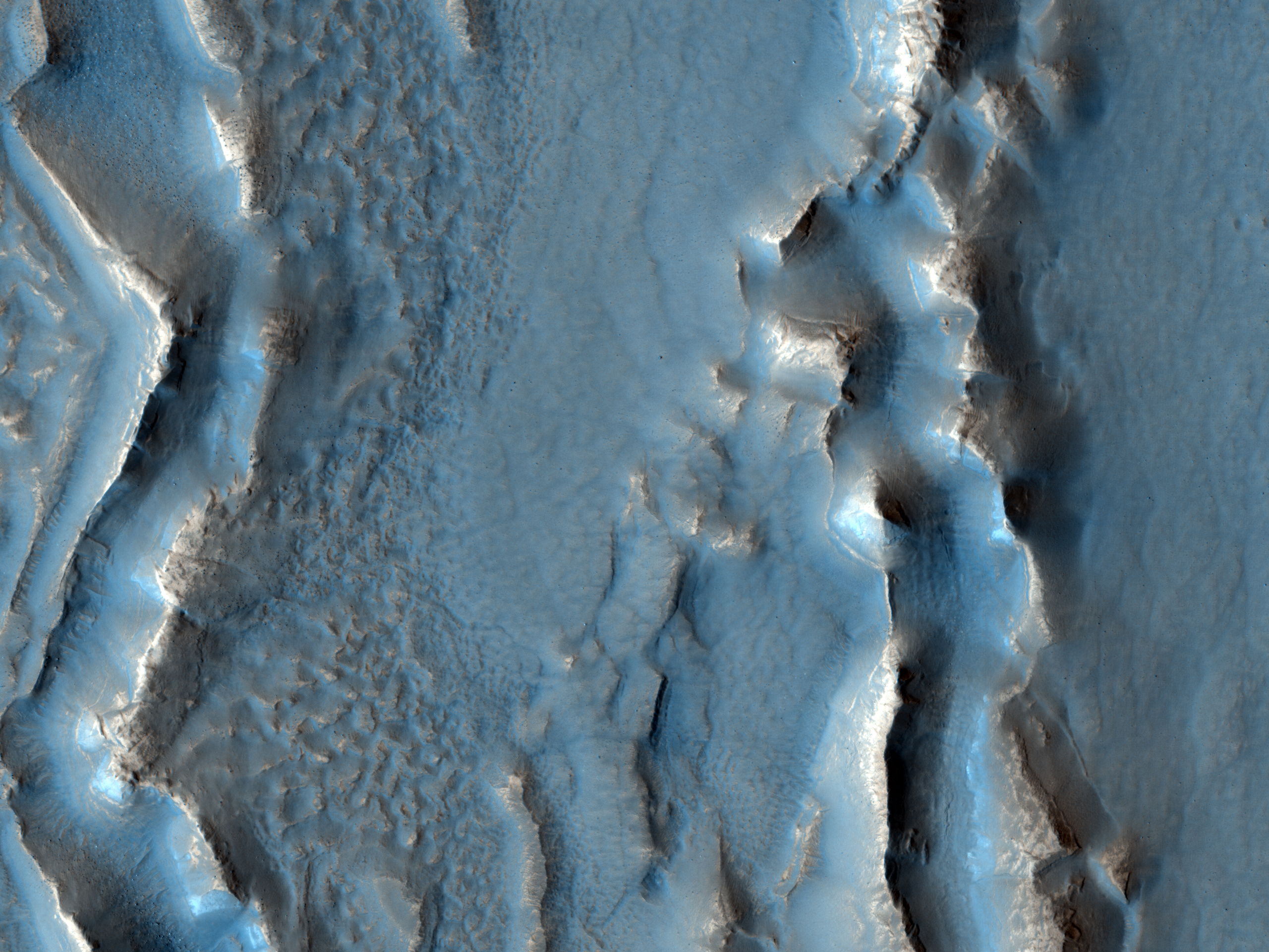
Today's Image of Mars shows possible clays and sulfates in Gale Crater, which is where Mars Science Laboratory (MSL) Curiosity will be landing on August 6 2012. Clays and sulfates are formed in the presence of water on Earth, and scientists use their abundance on Mars as proof that water once covered much of the Red Planet.

Click to see the original hi-res image
Credit: HiRISE


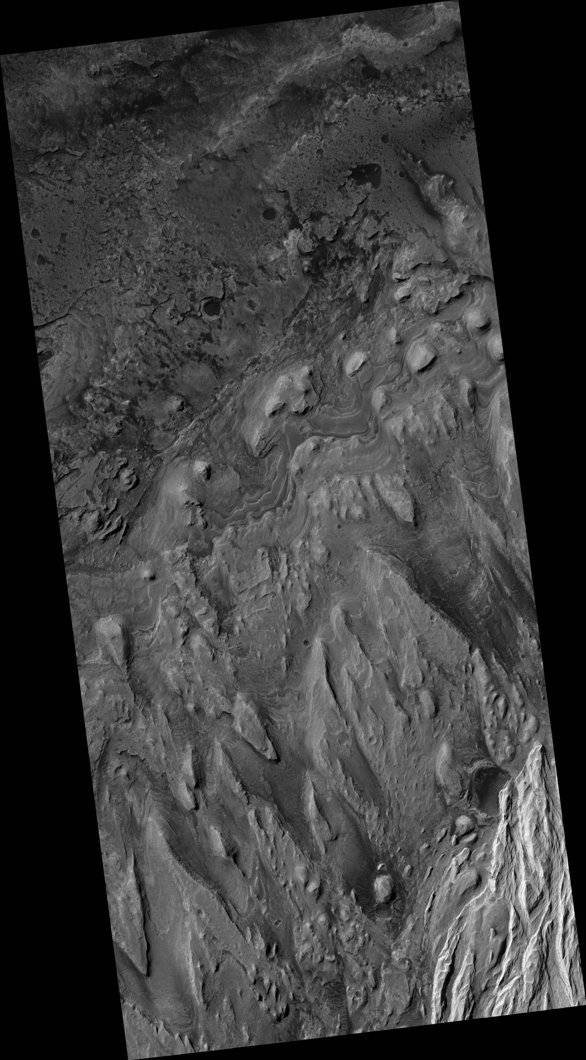
When MSL lands in Gale Crater it will examine other clays and sulfates within the 150km wide crater, in hopes of determining if Mars was ever capable of sustaining life. The age of the clays and sulfates will give us a better understanding of when water was present on the surface of Mars. Examining the exact composition of those clays will show us the acidity of that water, which is an important factor in determining if life as we know it could have existed on Mars.

If water is too acidic than most life that we've encountered on Earth would not be able to survive. Orbital instruments aboard Mars Reconnaissance Orbiter, Mars Express, Mars Odyssey Orbiter and other past and present orbiters has indicated that Mars contains some clays formed in highly acidic water, but it also contains some formed in more tolerable (neutral) water. Examinations of Gale Crater have led scientists to believe that the water once contained within it was close to neutral, and thus much more hospitable to life as we know it.

But only by further examination of the clays, sulfates, and other materials in Gale Crater will we know for sure! That is why Mars Science Laboratory Curiosity was sent! We have only to wait until August before the discoveries begin!

Mars Photo of the Day - June 6 2012

Today's Image of Mars is a picturesque example of what became of the rivers on Mars and the effects those ancient bodies of water had on the surface. You can see in this image that much of the terrain is composed of light and moderately toned layered material. The cratered, lower elevation areas tend to be darker.

Clicking on this image will take you to the original high resolution one from HiRISE. [See their caption]