Google+ Mars Travel: January 2013

Birds-Eye View of MSL Curiosity

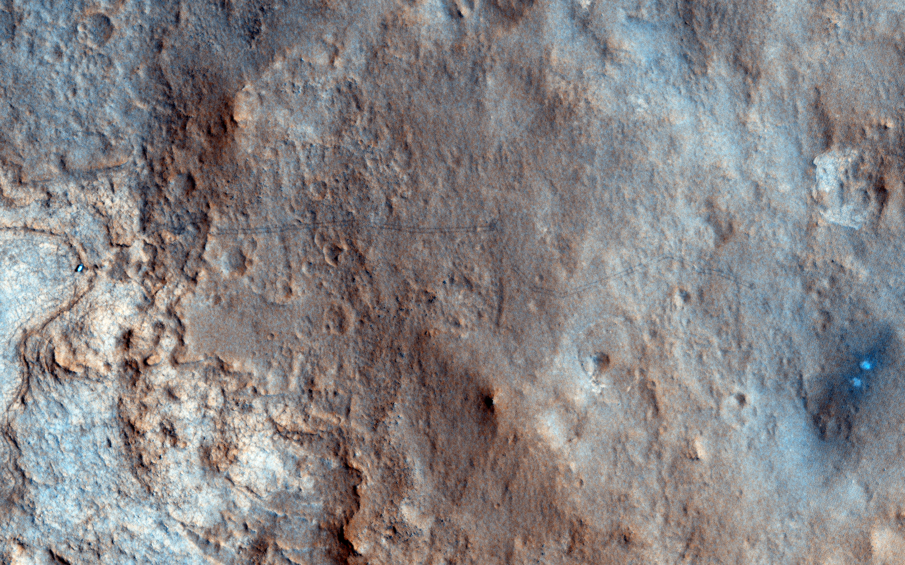
Take a look at HiRISE's birds-eye view of MSL Curiosity, taken on the 157th sol of it's mission in Gale Crater. In this image you can see the rover itself, as well as tracks left from MSL's movement across the Martian terrain (this is especially true if you click on the image). The bright white/blue dots on the right shows the the area that was directly below MSL's Sky Crane rockets. Because of wind and other factors, the earliest tracks from MSL have begun to fade, but fortunately they can still be made out in the larger high resolution version (just click the image below to see it)! 

Source: HiRISE

This image is quite significant because it is the first color image showing MSL's tracks from orbit. It is oftentimes these images that provide us perspective because they show us the impact we are having on this pristine planet. Every rover we send to Mars is breaking new ground, every image shows a never before seen world, every soil analysis enhances our understanding of the solar system and provides context for our place in the universe. 

McLaughlin Crater - A Once Lively Lake?

McLaughlin Crater on Mars may have once been home to a massive lake! That's according to new spectrometer date from NASA's Mars Reconnaissance Orbiter (MRO).

McLaughlin is a 92 kilometers (57 miles) in diameter and 2.2 kilometers (1.4 miles) deep. The crater's extreme depth tapped into typically unexposed underground channels of water, which then filled the crater.

Click to see larger, annotated, and captioned version from NASA
MRO discovered clays and carbonates, which only form in the presence of water, on the floor of McLaughlin Crater. We know small underground channels fed this massive lake because there is no evidence of any large outflow channels leading into the crater. Additionally, small channels within the crater end at a certain point on the crater wall, which was likely the level of of the lake.

This new discovery of clays and carbonates in McLaughlin Crater has added even more hope that life once, or maybe still does, exist on Mars. The presence of carbonates in particular indicates that the lake likely had low-acid content because carbonates generally do not remain preserved in high-acid environments. Life as we know is most likely to exist in low-acid environments, so having this knowledge makes scientists think this crater and the underground tributary channels may be the ideal place to search for evidence of past and/or present life.


First Use of MSL's Dust Removal Tool

The below image shows the first patch of rock on Mars that Mars Science Laboratory's (MSL) Dust Removal Tool (DRT) brushed off. This dust removal took place on the 150th Martian sol of MSL's mission (6 Jan 2013) on a rock named Ekwir_1. The cleared patch of rock is 47x62mm (1.85x2.44in).

Area cleared of dust on Ekwir_1 rock by Dust Removal Tool
Source: NASA/JPL (Click to see larger official image from NASA)
MSL's Dust Removal Tool is similar to Mars Exploration Rovers Opportunity and Spirit's Rock Abrasion Tool (RAT), except that MSL's tool is primarily used for dusting surfaces off, while the RAT is often used to grind/drill into the top layer off a rock, exposing the unweathered material beneath for further examination.

If you want to know what the DRT looks like, just take a look at the following image from NASA!

MSL's Dust Removal Tool (DRT) from two angles
Source: NASA/JPL
These tools to remove dust are essential to any Mars rover's mission because essentially the entire surface is covered by a fine layer of dust. There could be incredible minerals or even evidence of life below the dust, but we'd never discover it if we don't remove that surface layer. As MSL continues on toward Mount Sharp it will undoubtedly keep using its DRT to expose the beauty of Mars that lies only millimeters beneath the surface. 

When it does I'll be sure to post those images too!