Google+ Mars Travel: crater on Mars
Showing posts with label crater on Mars. Show all posts

Counting Impact Craters on Mars

NASA has recently finished a study in which they determined the approximate number of asteroid and comet impacts on Mars every year. Using data collected by Mars Reconnaisance Orbiter (MRO) scientists have estimated there are 200 small craters formed every year on Mars as a result of asteroid and comet impacts. These craters measure at least 3.9 meters (12.8 feet) across.

MRO was able to image craters previously detected by itself and other Mars orbiters. Images of the same spots on Mars are taken at different times, thus if an older image does not show a crater, but a more recent one does, we know the impact occured before the most recent image, but after the one previous. This technique allows scientists to more accurately determine the age of craters on the surface.

Understanding the frequency of impacts is important to our understanding of Mars' past and allows scientists to more accurately determine the age of features on the planet. A feature or region with less impact craters is much younger than one with more craters because we know that overtime a feature on Mars will accumulate more impacts. The science will never be perfect, but can at least give us a better understanding of Mars and its development.

For example, scientists will be better able to determine the age of Hadley Crater based on the number of small craters within it. Just look at the image below and you will see that even within Hadley Crater there are multiple smaller craters.

Click to see the original high resolution image from Mars Express [See ESA article]

Previous estimates placed the number of yearly impacts on the Martian surface at 3 to 10 times the amount recently calculated. Those previous studies were done in the 1960s and 1970s and based off studies of lunar craters. MRO's HiRISE Principal Investigator Alfred McEwen says that this new study means "Mars now has the best-known current rate of cratering in the solar system," meaning that of all the bodies in the solar system, Mars is the one we are best able to determine the frequency of asteroid and comet impacts on.

Source:
Dwayne Brown, Guy Webster, Daniel Stolte. NASA Probe Counts Space Rock Impacts on Mars. 15 May 2013.NASA http://www.nasa.gov/home/hqnews/2013/may/HQ_13-142_Mars_MRO_Craters.html (accessed 15 May 2013) 

Mars Travel's Mars Photo of the Day - 15 Sept 2012
Mars Photo of the Day - 20 Sep 2012

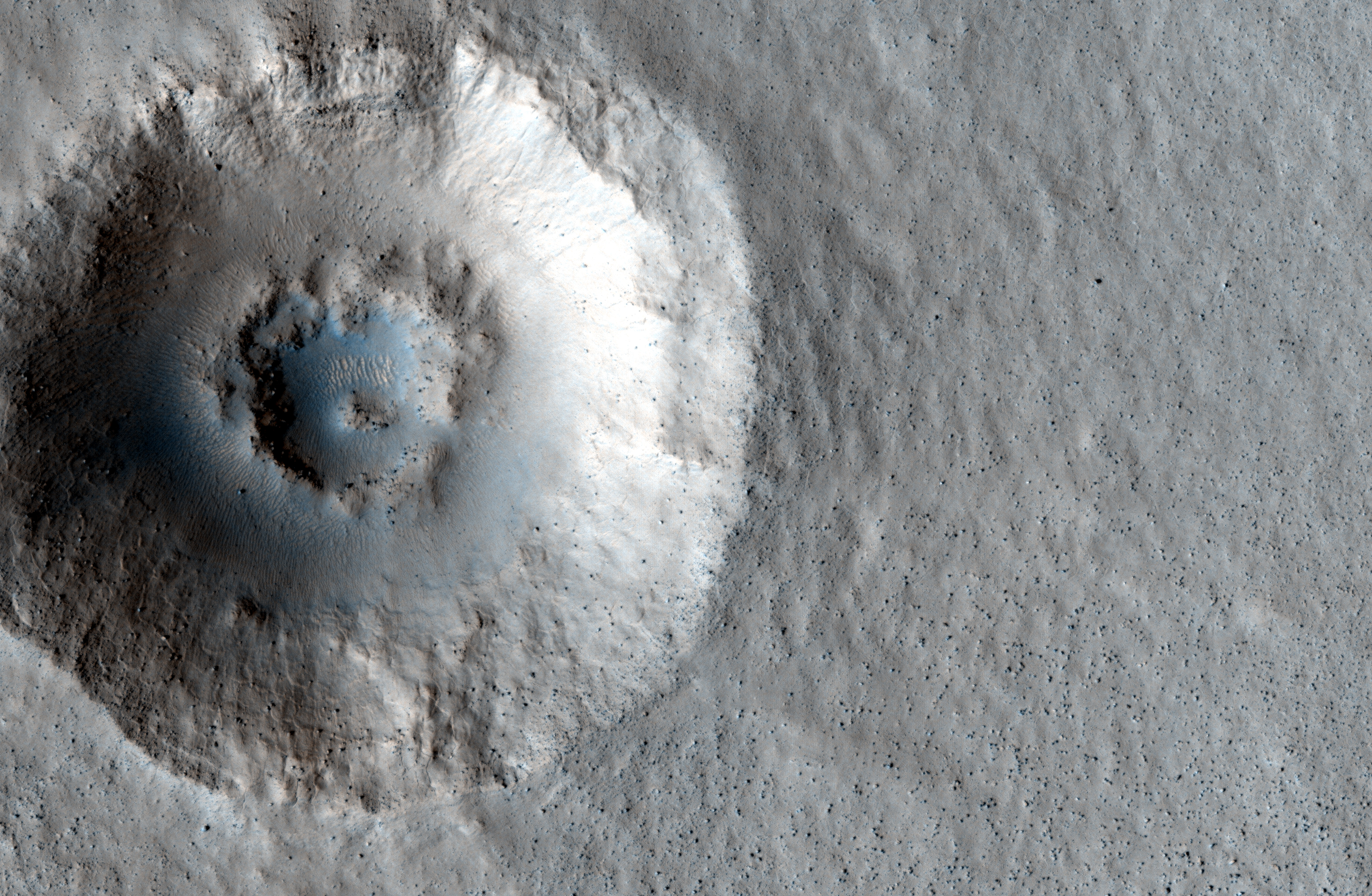
Today's Image of Mars shows two distinctive layers exposed in a 230m wide crater caused by a meteorite impact in the Northern Plains. The impact excavated material from both layers at different rates because the layers are different densities. If you want to conduct an experiment to see how this happens, follow these steps:
  • Fill a bowl halfway with water and freeze it. 
  • After it's frozen, place a layer of sugar (powdered or granular) over the surface.
  • (This is the messy part) Take a marble or other hard object and throw it down into the bowl. (The impact will eject a lot of sugar from the surface)
  • Carefully remove the marble.
  • Take a photo from above. You will notice that the marble made more of an impact in the sugar, but faced increased resistance when it hit the ice. 
This is a simplified version of what happened when the meteorite created this impact. The layer under the surface was denser so the meteorite faced much more resistance and excavated the material at a much lower rate, as seen below.

Click for high resolution image from HiRISE. [See their caption]
Radar images taken by SHARAD, the radar instrument aboard the Mars Reconnaissance Orbiter indicate the presence of ice below the surface, which makes this area a potential site for future exploration of Mars. If we can access ice beneath the surface of Mars then we could use it not only for sustenance, but as a source of fuel for future missions to Mars.


Mars Photo of the Day - 21 Jul 2012

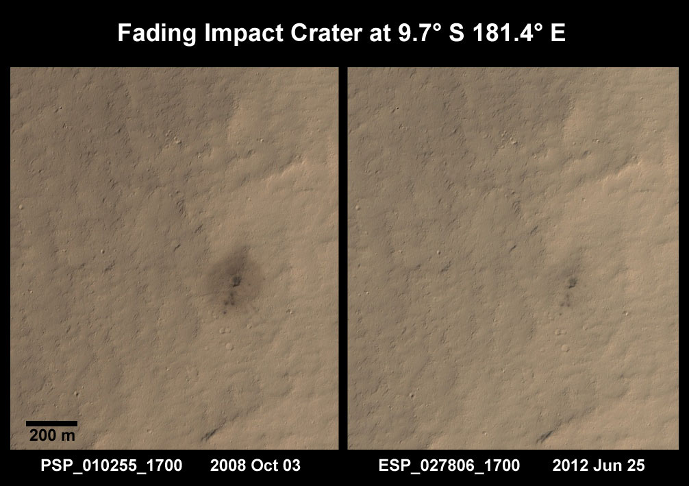
Today we'll take a look at two images of the same area taken a few years apart. Sometime between July 2005 and October 2008, a weak impactor broke up in the atmosphere of Mars and it's constituent parts hit the surface. Scientists know this because a THEMIS image from July 2005 of this area shows no indication that an impact had taken place, while a subsequent image taken by the Context Camera (CTX) aboard Mars Reconnaissance Orbiter in August 2008 showed the surface peppered with small impacts and a dark ejecta blanket. This led the HiRISE team to investigate the impact site in October 2008.
Clicking on this image will take you to the original HiRISE caption referencing this image.

In the first HiRISE image we can see the small impact sites and a dark ejecta blanket that seems to stem from the largest of the craters. In the subsequent image taken a few years later we see that the dark ejecta blanket has begun fading. This means that the wind either blew away the dark ejecta, or covered it with the surrounding lighter sediments.

Understanding this process and how long it takes is extremely important to future exploration of Mars. When we understand how fast erosion occurs on Mars we can infer how fast the wind is blowing and the amount of sediment that it picks up. Knowing this will help us to take the appropriate precautions that may end up saving lives and equipment. When we know how ferocious erosion will be we will be able to create barriers that can withstand that erosion.

Additionally, if we understand the rate at which erosion occurs we can ensure that we choose a more permanent features as navigational references once we do send a manned mission to Mars. This will ensure that people don't get lost or lose sight of their shelter because they expect to see a feature that has recently eroded away. Studying images like the two below will increase scientists understanding of the eroding elements on Mars, and help us to better prepare for the time when we do send a manned mission to Mars.

Mars Photo of the Day - Dec 12 2011

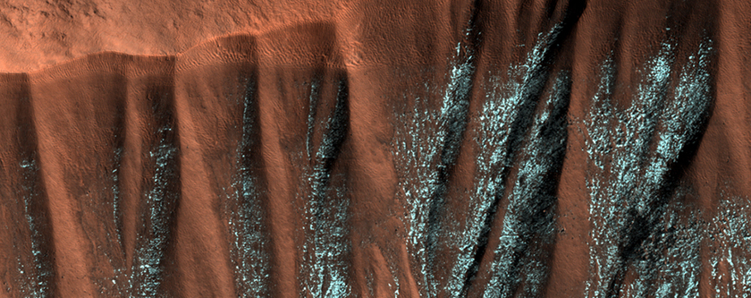
Today's Image of Mars shows frosted gullies in a North Polar region crater. This image was taken in the summer months on Mars. The frost has survived because it lies within the North facing alcoves of the gully and is constantly shrouded in shadow. There are similar gullies on the opposite side of the crater, but because they are facing south the frost inside them has melted.

The gullies depicted in this image have the large alcove at the top of the crater wall and channels that flow down into the crater. Some of these gullies show current activity, but it seems that the most activity is at the height of the winter season when the temperatures are the lowest, which leads scientists to believe that the activity is caused by falling loose material and not liquid water.

This image was taken by HiRISE. Clicking on the image will take you to the original captioned image from them.


If you like the HiRISE images showcased in the Mars Photo of the Day posts I encourage you to enter for a free 2012 HiRISE Calendar

Mars Photo of the Day - Nov 22 2011

Today's Image of Mars is of a crater filled in by lava flows from the volcano Arsia Mons, one of the northern most Tharsis volcanoes. 

What's amazing about this crater is the fact that the rim remains almost entirely intact.  Oftentimes all evidence of an impact will be erased by a lava flow, but not in this case. The lava flows surrounded this crater and eventually broke through the crater rim, filling it to the same level as the surrounding terrain, but the rim is still distinct.

Clicking this image will take you to the original captioned image from Mars Odyssey Orbiter's THEMIS.

Source: THEMIS

Mars Photo of the Day - Oct 6 2011

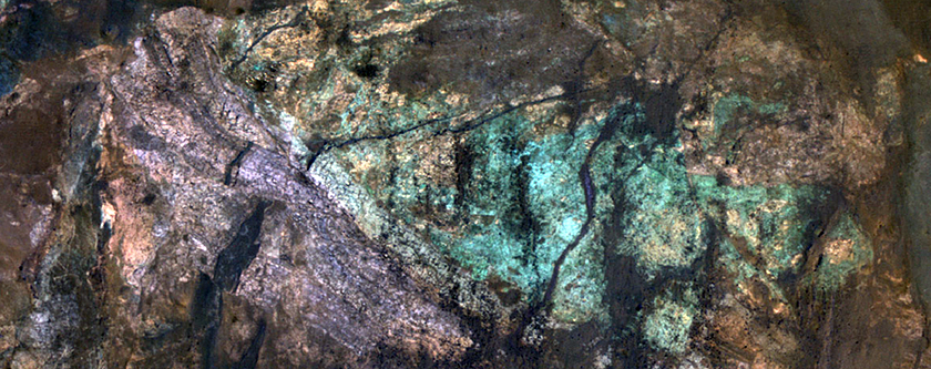
Today's Image of Mars is of a central peak in one of Mars' unnamed craters. These colorful rocks are the result of variations in mineral content due to water activity sometime in Mars' past. 

Who would have guessed that Mars could be home to such a beautiful array of colors?

Click the image to see the original captioned photo from HiRISE.