Google+ Mars Travel: Mount Sharp
Showing posts with label Mount Sharp. Show all posts

The Importance of MSL Curiosity's Self-Portraits

Below is a self portrait of Mars Science Laboratory Curiosity at Rocknest created by combining dozens of high resolution images taken by the rover on 31 October and 01 November 2012. A previous self-portrait at the same location did not include the magnificent view of MSL's ultimate target, Mt. Sharp, that this photo does.

You can see in this photo the five scoops MSL took out of the soil at Rocknest in order to first calibrate its sample-handling mechanisms, then test the Martian soil to determine its content. You can also see tire tracks made by the rover as it moved into Rocknest.

If you click on the image below and zoom in you will be better able to appreciate the majesty of Gale Crater's rocky terrain. You will also get a better view of Mount Sharp and the clays that lie around the base of Gale Crater's central uplift.

Source: NASA/JPL

Self portraits like the ones above serve a couple key purposes, one of which may not be so obvious:

MSL Curiosity Self Portrait - Rocknest

This self-portrait of Mars Science Laboratory Curiosity is a masterpiece.

Click to see the high resolution version from NASA! It's worth it!

This image is a mosaic of 55 high resolution images taken by the rover's Mars Hand Lens Imager (MAHLI) taken on Halloween 2012. In this image the rover is located at Rocknest, the location in Gale Crater where MSL took its first scoop sampling. You can see four markings in front of the rover where MSL scooped the surface.

On the right side of this image you can see the central mound, Mount Sharp rising above the horizon, while in the background on the left you can see the northern wall of Gale Crater. 

Self-portrait images like this one let MSL engineers and mission specialists examine the state of the rover. Understanding the rover's condition will help to extend it's life. This self-portrait technique has been used on other Mars rovers, including Opportunity and Spirit, and helped to increase their life more than tenfold. 

Mars Photo of the Day - 10 Oct 2012

Today's Image of Mars shows an area at the base of Gale Crater's Mount Sharp where Mars Science Laboratory Curiosity will eventually explore. The darkest colored materials are deposits small grained, windblown sand. The blue areas represent unaltered igneous rock, whereas the lighter brownish-red colors are indicative of the same type of rock altered by what most scientists believe was water. 

MSL Curiosity's mission is to search for signs that Mars could have once supported life as we know it; examining minerals that have been altered by the presence of water will help us to determine that. Studying the chemical composition of these rocks will provide us with unparalleled insight into the past environment on Mars. 

Clicking on this image will take you to the original high resolution image. [HiRISE caption for the image]

Mars Photo of the Day - 15 Aug 2012

Today's Image of Mars shows Mars Science Laboratory and the surrounding terrain in color, as taken by Mars Reconnaissance Orbiter's HiRISE camera. The blue in this image would look grey to the human eye, but the color was enhanced to make differentiating terrain easier.

Mount Sharp, MSL's ultimate destination is outside of this frame to the southeast, where up is North. To give you an idea of scale, MSL is about 300m from the bottom of the image. As MSL moves south toward Mount Sharp, it will encounter much different terrain, including dune fields. In the days, weeks, and months to come MSL will study this terrain and the material that makes it up, providing us an unprecedented close up look at the clays and sulfates making up the base of Mount Sharp.


Mars Photo of the Day - 6 Aug 2012

Today's Image of Mars comes from Mars Science Laboratory and shows Mount Sharp, the 5.5km high central uplift of Gale Crater. MSL will be studying Mount Sharp as it attempts to determine whether Mars once did, or still does have the building blocks for life.

Click to see the high res image from MSL Curiosity
Source: NASA/JPL
Mount Sharp's base is thought to be at least 2 billion years old and it is contains numerous layers of clays and sulfates, two materials that are only known to form in the presence of water. The layers directly on top of those are comprised primarily of sulfates, with very few clays, which implies that they were formed in an environment where Mars was becoming drier and water was evaporating.

By studying these layers scientists can verify that Gale Crater once contained a lake of water. They will also give us insight as to the time frame the water begin disappearing from the surface of Mars! There is so much that MSL will learn from examining Mount Sharp; what it will find only time will tell!


What is Mars Science Lab Looking for?

Below is an image pointing out clays and sulfates in the lower portion of Mount Sharp within Gale Crater. Mars Science Laboratory (MSL) Curiosity is set to land in Gale Crater on Monday 6 Aug at 0100ET.  From there MSL will begin examining the surrounding terrain, with special emphasis on the clay minerals and sulfates because those were likely formed during a period when Mars was more hospitable to life as we know it.

Source: Space.com
We know this because clays and sulfates are formed in the presence of water. Orbital studies of Gale Crater have indicated that the water that once filled the crater was less acidic than in other areas previously studied on Mars. Water is more hospitable to life when it is less acidic, so scientists hope that examining the clays and sulfates formed in that water will tell them whether Mars was, or still is a conducive environment to life as we know it. 

A lot of people think that Mars Science Laboratory was sent to Mars to find life, but this isn't the case. It is landing on Mars to determine if the conditions on Mars were or still are favorable to life. That doesn't mean MSL couldn't find life, it just means that it isn't searching for it.

Source: NASA/JPL

So why does Mars Science Laboratory's mission matter? If we find out that Mars was or still is an environment that can sustain life, it will raise our hopes that it did once contain life. The mission will examine the layers in Mount Sharp, giving us a better understanding of the timeframe during which the water on Mars disappeared. If we know when the water on Mars disappeared we can better determine why and perhaps learn how to prevent such a catastrophe from happening to us on Earth!

When we determine how long ago water was abundant on Mars we can start narrowing down our search for life by only examining sediments and other material formed during those time periods since water is generally thought to be necessary for the development of life. So Mars Science Laboratory is key to understanding more about the past on Mars and in the solar system!

Weekend Feature: Gale Crater

Looking down on Mars we see Gale Crater as a crater among many craters, but even from this distant perspective Gale Crater is unique, special, and above all, intriguing. In the image below we can spot the 150km in diameter Gale Crater because of its massive central uplift, Mount Sharp, which rises 5.5 km above the northern crater floor and 4.5 km above the southern crater floor. It is Mount Sharp that makes Gale Crater so intriguing and worthy of future study.


Mount Sharp's base is thought to be at least 2 billion years old. It is comprised of clays and sulfates, two materials that are only known to form in the presence of water. The layers directly on top of those are comprised primarily of sulfates, with very few clays, which implies that they were formed in an environment where Mars was becoming drier and water was evaporating. See the next image for an idea of what these intriguing layers look like.

Mars Photo of the Day - Apr 1 2012

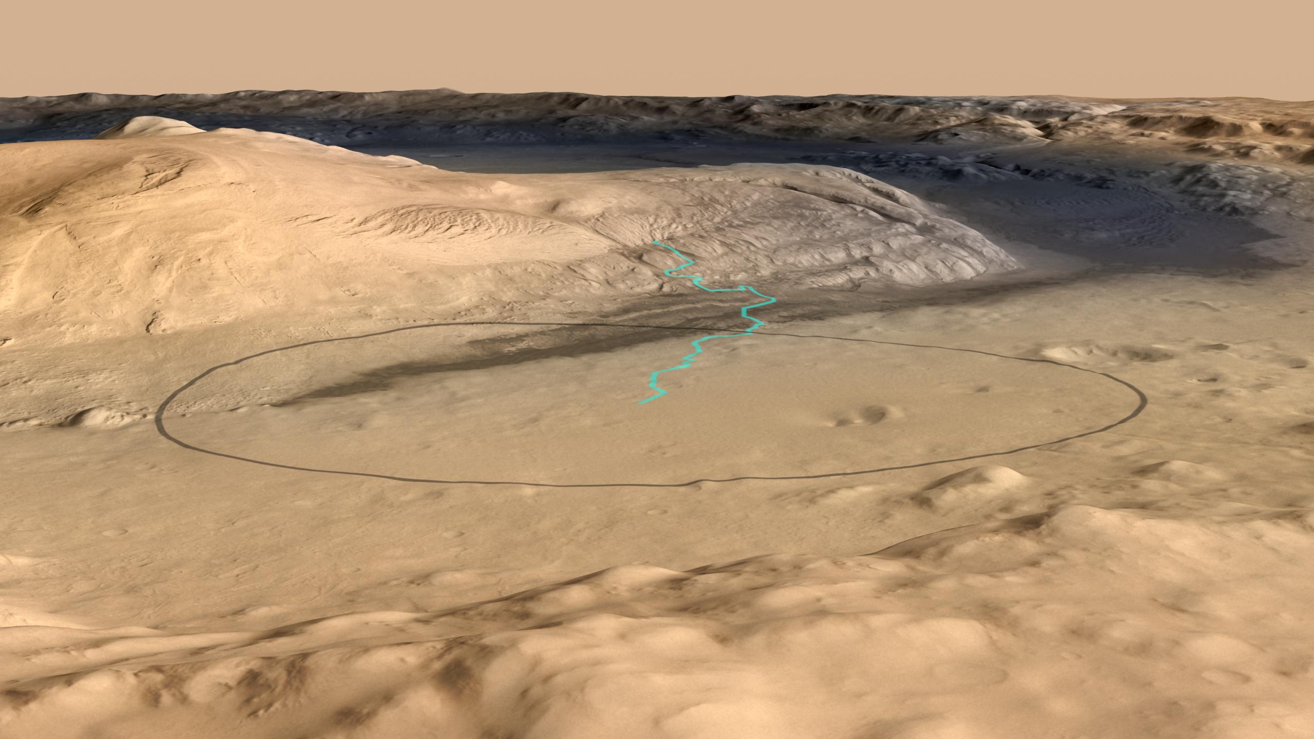
Today's Image of Mars shows the landing site for Mars Science Laboratory Curiosity at the foot of Mount Sharp, the 5km high central mound in Gale Crater. The turquoise line shows the expected path of MSL after it lands and begins navigating its way up Mount Sharp. The black oval measures about 20km by 25km and is the area in which MSL Curiosity has a 99% probability of landing.

The lowest portion of Mount Sharp is comprised of clays and sulfates, materials which are formed in the presence of water. The overlying layers contain sulfates, but very little clay, indicative of an environment in which water was evaporating and Mars was becoming drier. Scientists hope that studying Mount Sharp's layers can provide insights into the past Martian climate and give them a better idea as to whether Mars was once, or may still be habitable.

This image combines data from the High Resolution Stereo Camera on the European Space Agency's Mars Express orbiter, with data from the Context Camera on NASA's Mars Reconnaissance Orbiter, and color information from the Viking Orbiter. Clicking on this image will take you to the original higher resolution image from NASA. [See the NASA article on Mount Sharp]