Google+ Mars Travel: Gale Crater
Showing posts with label Gale Crater. Show all posts

MSL Curiosity - One Year on Mars

One year ago today Mars Science Laboratory touched down on Mars. Since August 5th 2012 Curiosity has transmitted over 190 gigabits of data, sending more than 70,000 images back to Earth. Not only that, but Curiosity has driven over one mile and fired its laser 75,000 times at 2,000 different targets.

Click for larger image from NASA/JPL
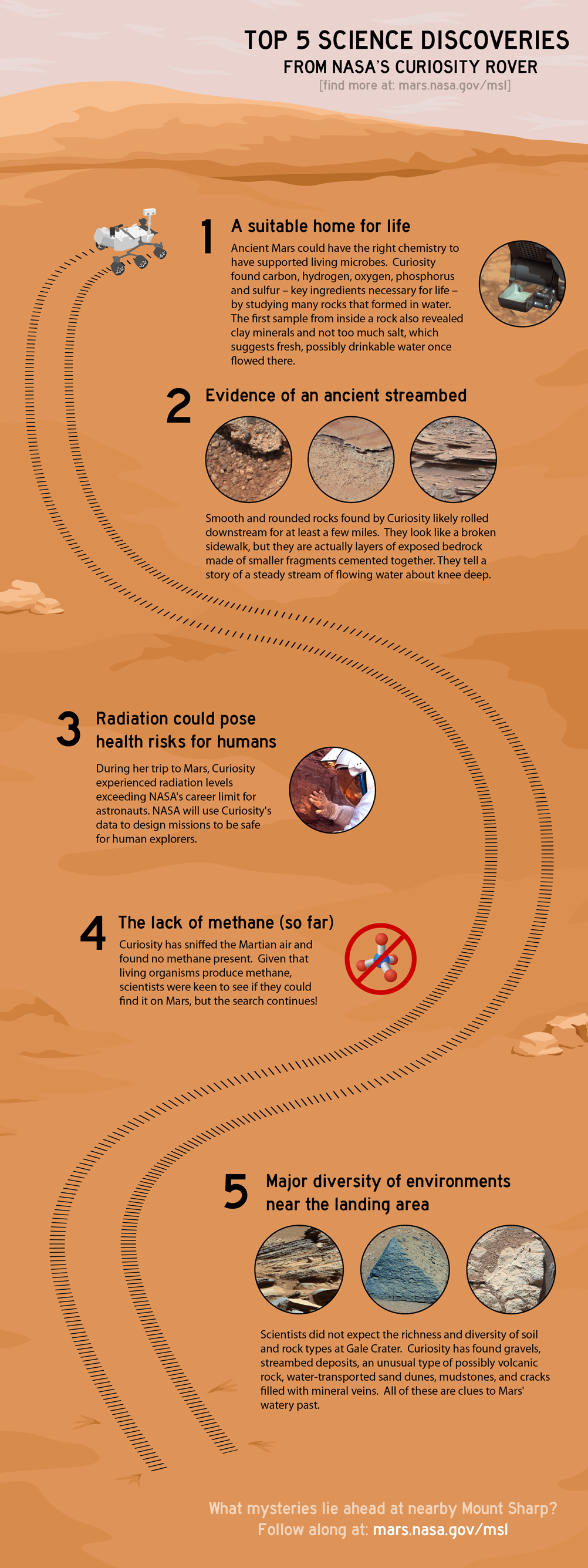
With all that activity, many discoveries have been made, the most important of which have been identified in NASA's infographic on the right. Click the image to see the larger version from NASA.

While MSL's overall mission is to scale Mount Sharp at the center of Gale Crater and study it's various layers, the science team decided to examine nearby outcrops Glenelg and Yellow Knife which is where many of the discoveries to date have been made.

One of the most significant discoveries was that Mars once had an environment that was conducive to microbial life, but that Mars somehow lost most of it's atmosphere "through processes that occurred at the top of the atmosphere" (NASA)

The next NASA mission to Mars, Mars Atmosphere and Volatile Evolution (MAVEN), launches in November of this year and will attempt to determine what caused the atmosphere to bleed into space billions of years ago.

MSL Curiosity has also discovered evidence of an ancient streambed in the form of smooth, rounded sedimentary rocks, that likely rolled with a current for many miles. Bedrock, made up of millions of smaller compacted sediments has been discovered. This type of compaction is only known to occur in the presence of flowing water.

Further evidence that Mars once contained water has been found in the form of "gravels, streambed deposits, an unusual type of possibly volcanic rock, water-transported sand dunes, mudstones, and cracks filled with mineral veins." (NASA)

For a better understanding of MSL Curiosity's  one mile journey, take a look at the below  annotated image from NASA.

Click to see a larger version of this annotated image from NASA
MSL Curiosity's journey began one year ago today, and in that time it has traveled one mile and made numerous discoveries. The next year will see the rover complete its primary goal of  scaling Mount Sharp and provide even more insight into the past and current environment on Mars. Who knows what amazing discoveries will be made in the next year!
1.3 Billion Pixel Mosaic from Mars Science Laboratory

Below is a panoramic mosaic of Mars compiled from almost 900 images taken by Mars Science Laboratory. Click on the image to see the interactive photo with over 1.3 billion pixels, then zoom in on any feature that interests you!

Click above to view the interactive 1.3 billion pixel image from MSL Curiosity!
Source: NASA/JPL

This images used to create this mosaic was taken while Curiosity was at Rocknest between October 5 and November 16 2013. The center of the image is directly south of the rover, while the right and left edges are north of it.

Definitely click on this image so that you can view all 1.3 billion magnificent pixels of Mars!

Birds-Eye View of MSL Curiosity

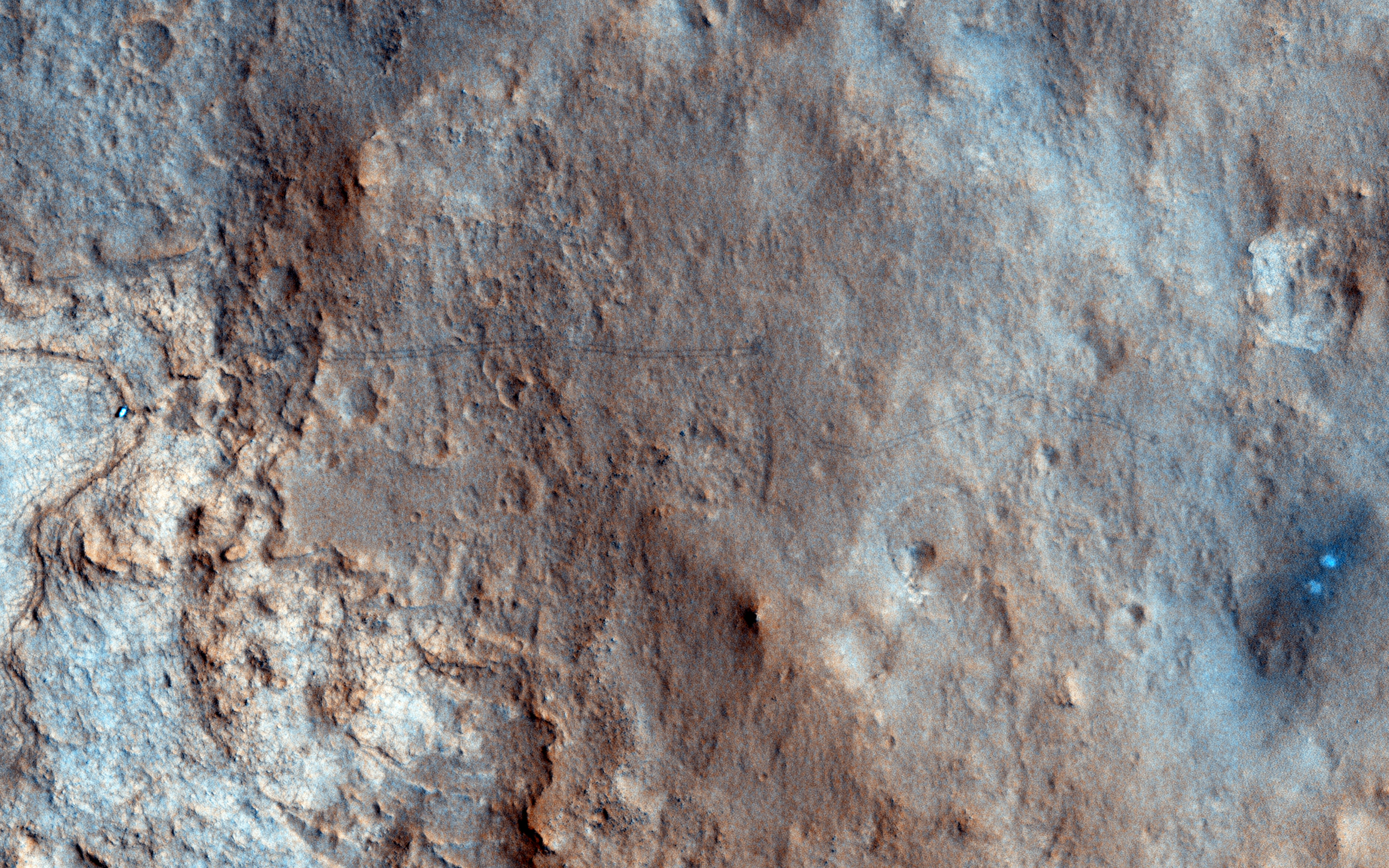
Take a look at HiRISE's birds-eye view of MSL Curiosity, taken on the 157th sol of it's mission in Gale Crater. In this image you can see the rover itself, as well as tracks left from MSL's movement across the Martian terrain (this is especially true if you click on the image). The bright white/blue dots on the right shows the the area that was directly below MSL's Sky Crane rockets. Because of wind and other factors, the earliest tracks from MSL have begun to fade, but fortunately they can still be made out in the larger high resolution version (just click the image below to see it)! 

Source: HiRISE

This image is quite significant because it is the first color image showing MSL's tracks from orbit. It is oftentimes these images that provide us perspective because they show us the impact we are having on this pristine planet. Every rover we send to Mars is breaking new ground, every image shows a never before seen world, every soil analysis enhances our understanding of the solar system and provides context for our place in the universe. 

The Importance of MSL Curiosity's Self-Portraits

Below is a self portrait of Mars Science Laboratory Curiosity at Rocknest created by combining dozens of high resolution images taken by the rover on 31 October and 01 November 2012. A previous self-portrait at the same location did not include the magnificent view of MSL's ultimate target, Mt. Sharp, that this photo does.

You can see in this photo the five scoops MSL took out of the soil at Rocknest in order to first calibrate its sample-handling mechanisms, then test the Martian soil to determine its content. You can also see tire tracks made by the rover as it moved into Rocknest.

If you click on the image below and zoom in you will be better able to appreciate the majesty of Gale Crater's rocky terrain. You will also get a better view of Mount Sharp and the clays that lie around the base of Gale Crater's central uplift.

Source: NASA/JPL

Self portraits like the ones above serve a couple key purposes, one of which may not be so obvious:

What Has MSL Curiosity Discovered?

Click for showcased image/post from Mars Travel
On 20 Nov 2012 MSL Curiosity's chief scientist John Grotzinger made a tantalizing announcement. He told NPR that MSL's Sample Analysis at Mars (SAM) Instrument discovered something extremely interesting, claiming that "the data is gonna be one for the history books. It's looking really good." He went on to say that the discovery was made from a soil sample taken by the SAM Instrument. This was most likely one of the five scoop samples taken from Rocknest (imaged right).

But what could it be? 

Could organics have been discovered? Or evidence of past or present life? Such a finding would shake the foundations of not only the scientific community, but of humanity's perception of themselves in the grand scheme of the universe. In a previous post (excerpted below) I delved into why finding life on Mars would be significant and what it would mean for us here on Earth.

Should we find life on Mars, there are two possible scenarios:

MSL Curiosity Self Portrait - Rocknest

This self-portrait of Mars Science Laboratory Curiosity is a masterpiece.

Click to see the high resolution version from NASA! It's worth it!

This image is a mosaic of 55 high resolution images taken by the rover's Mars Hand Lens Imager (MAHLI) taken on Halloween 2012. In this image the rover is located at Rocknest, the location in Gale Crater where MSL took its first scoop sampling. You can see four markings in front of the rover where MSL scooped the surface.

On the right side of this image you can see the central mound, Mount Sharp rising above the horizon, while in the background on the left you can see the northern wall of Gale Crater. 

Self-portrait images like this one let MSL engineers and mission specialists examine the state of the rover. Understanding the rover's condition will help to extend it's life. This self-portrait technique has been used on other Mars rovers, including Opportunity and Spirit, and helped to increase their life more than tenfold. 

Closeup of Bright Object in 'Rocknest'

Today's Image of Mars is a closeup of a mysterious bright object located at Rocknest on Mars taken by MSL Curiosity's Mars Hand Lens Imager (MAHLI). The image shows an area spanning only 4cm across, which should give you a better idea of how big these bright particles are. MSL took this image after it had taken a scoop of the terrain.

Click this image to see the high resolution image from NASA. 
The MSL team was originally worried that the bright objects could be a part of the rover that had fallen off, as this has already happened once before, but after further image analysis it was determined that these bright particles are natural to Mars. 

Mars Photo of the Day - 14 Oct 2012

Today's Image of Mars is an annotated photo of the rock Jake Matijevic, which MSL Curiosity recently examined with two different instruments. The image was taken on 21 Sep 2012, or Sol 46 of MSL's mission on Mars. 

Click to see original high resolution image from NASA.

The purple circles represent areas where the rover's Alpha Particle X-ray Spectrometer trained its gaze. The red dots are where Curiosity's ChemCam zapped the rock with its laser and examined the chemical composition of the vapors. Understanding the chemical makeup of rocks like Jake Matijevic will give scientists a better idea of the environment in which they were created.

Mars Photo of the Day - 10 Oct 2012

Today's Image of Mars shows an area at the base of Gale Crater's Mount Sharp where Mars Science Laboratory Curiosity will eventually explore. The darkest colored materials are deposits small grained, windblown sand. The blue areas represent unaltered igneous rock, whereas the lighter brownish-red colors are indicative of the same type of rock altered by what most scientists believe was water. 

MSL Curiosity's mission is to search for signs that Mars could have once supported life as we know it; examining minerals that have been altered by the presence of water will help us to determine that. Studying the chemical composition of these rocks will provide us with unparalleled insight into the past environment on Mars. 

Clicking on this image will take you to the original high resolution image. [HiRISE caption for the image]

Studying MSL's Tracks Will Help Future Missions to Mars

Take a look at this remarkable image from HiRISE showing Mars Science Laboratory Curiosity and the tracks it made during the first few drives in Gale Crater. Scientists will be keeping a close eye on these tracks so as to track the rate of surface change on Mars. 

Click to see high resolution version from HiRISE.

Unlike Earth's Moon, Mars does have wind and other weather, so tracks will get covered up. Examining these tracks will let scientists determine the quantity and frequency of dust deposits in Gale Crater, as well the rate of erosion. Knowing how often features on the surface of Mars can change or be covered up will help current and future missions to Mars; let me explain how:

Imagine a Mars rover takes a long distance shot and sees something slightly protruding out of the surface. If we have a good idea of the rate of change on Mars then we can determine how long that feature will be there before getting covered up. If it will be covered up in a matter of days then it would become a higher priority then something that might be visible for a few weeks or months.

If you send a manned mission to Mars it is essential that they are knowledgeable about the rate of surface change. If you were going to take a walk on Mars you would make some reference points so as not to get lost. If you weren't aware of the rate of change you might use a field of hematite (blueberries) to the right of base camp as a reference point, not realizing that it might be covered up in a couple hours. You could get lost because you didn't know how fast something could get covered up!

As you can see, images like the one above are essential to our understanding of Mars and could help us save the lives of future explorers and billions in hardware!


Mars Photo of the Day - 25 Aug 2012

Today's Image of Mars shows the first tracks left by Mars Science Laboratory since it's arrival in Gale Crater. On 22 Aug 2012 MSL made it's first drive, moving to a spot 4.5m from it's landing site before rotating 120 degrees and reversing 2.5m. The rover is now 6m away from it's landing site, which is now called Bradbury Landing.

Unlike on the Moon, these tracks will likely be covered up in the weeks and months to come because of weather on Mars. The most likely ways these tracks will be erased is by a dust devil or dust storm, a weather phenomena that is a frequent occurrence on Mars.

To the left and right of the track marks you can see marks left from the descent stage landing. At the top of this image close to the center you can see the lower slopes of Mount Sharp, MSL's ultimate destination. Clicking on this image will take you to the original high resolution image from NASA.

Credit: NASA/JPL

Mars Photo of the Day - 15 Aug 2012

Today's Image of Mars shows Mars Science Laboratory and the surrounding terrain in color, as taken by Mars Reconnaissance Orbiter's HiRISE camera. The blue in this image would look grey to the human eye, but the color was enhanced to make differentiating terrain easier.

Mount Sharp, MSL's ultimate destination is outside of this frame to the southeast, where up is North. To give you an idea of scale, MSL is about 300m from the bottom of the image. As MSL moves south toward Mount Sharp, it will encounter much different terrain, including dune fields. In the days, weeks, and months to come MSL will study this terrain and the material that makes it up, providing us an unprecedented close up look at the clays and sulfates making up the base of Mount Sharp.


The View From MSL Curiosity's Gale Crater Landing Site

As Mars Science Laboratory looks around its landing spot in Gale Crater, what does it see? This! 


You need to click on the image to see it in magnificent high resolution! Just looking at it you can see that the terrain looks very similar to something you might see in the southwestern United States. This mosaic combines 79 different images taken by MSL's Mastcam since the rover's arrival on Mars. The black overlays you see are areas that were unable to be processed or which were lost during transmission back to Earth.

What can we see of note in this image?

We can see the area excavated by the blast of MSL's descent stage engines. Of most interest to scientists is the uppermost layer of fine material embedded with rock fragments. The characteristics of the exposed sediments will tell scientists a lot about the conditions under which they formed and will give them a greater understanding of the past Martian environment.


In the mosaic you can also see the rim of Gale Crater about 18 km north of MSL. There you can see where a network of valleys are thought to have entered into Gale Crater in the distant past.


This is actually the first time that a river system has been imaged from the surface of Mars! MSL will not be investigating this particular fluvial system because it's main target, Mount Sharp, is to the south, but the images it provides from this distance are still the most detailed images we have and will tell us a lot about Martian river systems!

In the days and weeks to come there will be much more to discover about Gale Crater! Keep checking back for the latest and greatest!


Mars Photo of the Day - 10 Aug 2012

Today's Image of Mars shows where all the hardware for Mars Science Laboratory (MSL) ended up 24 hours after landing. If you click on this image you can see the HiRISE high resolution image, in which you can spot the parachute, back shell, heat shield, sky crane, and MSL itself!

The reason you see dark patches is because the impact and/or the thrusters blew away the light surface layering of dust, revealing the darker soil underneath. 


Mars Photo of the Day - 6 Aug 2012

Today's Image of Mars comes from Mars Science Laboratory and shows Mount Sharp, the 5.5km high central uplift of Gale Crater. MSL will be studying Mount Sharp as it attempts to determine whether Mars once did, or still does have the building blocks for life.

Click to see the high res image from MSL Curiosity
Source: NASA/JPL
Mount Sharp's base is thought to be at least 2 billion years old and it is contains numerous layers of clays and sulfates, two materials that are only known to form in the presence of water. The layers directly on top of those are comprised primarily of sulfates, with very few clays, which implies that they were formed in an environment where Mars was becoming drier and water was evaporating.

By studying these layers scientists can verify that Gale Crater once contained a lake of water. They will also give us insight as to the time frame the water begin disappearing from the surface of Mars! There is so much that MSL will learn from examining Mount Sharp; what it will find only time will tell!


MSL Curiosity - The First Week

When Mars Science Laboratory Curiosity begins its entry, descent and landing (EDL) it will go through 7 minutes of terror, as the largest payload ever to touch down on Mars slows from over 21,000 to 3.6km/hr as it maneuvers to the surface. If all goes to plan we will get confirmation of MSL touchdown at 0131:37EDT (0531:37UT) in Gale Crater near the base of Mount Sharp, thus beginning the most heavily anticipated Mars mission since Mariner 4 first imaged the Red Planet in July 1965.


The European Space Agency's Mars Express will be in position to image MSL during the different stages of EDL. It will begin monitoring MSL 45 minutes prior to it entering the Martian atmosphere and continue to do so after touchdown. The ESA will be working extensively with NASA throughout MSL's mission. [Details of ESA-NASA cooperation]

Click for larger image with stages of MSL's Entry, Descent & Landing
Credit: ESA/Mars Express
Upon landing MSL will remain in position for approximately 5 days, during which time mission control will ensure the ground right below the rover is safe to drive on. They will also use this time to deploy the high gain antenna, mast and sampling system, while ensuring that everything else deployed properly and is in working order. To get an idea of what MSL is carrying, click the image to your right.

Following the initial system checks MSL will make its first drive through uncharted Martian terrain and begin work to determine if the conditions on Mars were or still are favorable to life.

As many scientists have proclaimed. The most exciting aspect of MSL's mission is that we really don't know what we'll find in Gale Crater! One thing is for sure; MSL's journey will be new, informative, and exciting, as exploration of the unknown always is!

What is Mars Science Lab Looking for?

Below is an image pointing out clays and sulfates in the lower portion of Mount Sharp within Gale Crater. Mars Science Laboratory (MSL) Curiosity is set to land in Gale Crater on Monday 6 Aug at 0100ET.  From there MSL will begin examining the surrounding terrain, with special emphasis on the clay minerals and sulfates because those were likely formed during a period when Mars was more hospitable to life as we know it.

Source: Space.com
We know this because clays and sulfates are formed in the presence of water. Orbital studies of Gale Crater have indicated that the water that once filled the crater was less acidic than in other areas previously studied on Mars. Water is more hospitable to life when it is less acidic, so scientists hope that examining the clays and sulfates formed in that water will tell them whether Mars was, or still is a conducive environment to life as we know it. 

A lot of people think that Mars Science Laboratory was sent to Mars to find life, but this isn't the case. It is landing on Mars to determine if the conditions on Mars were or still are favorable to life. That doesn't mean MSL couldn't find life, it just means that it isn't searching for it.

Source: NASA/JPL

So why does Mars Science Laboratory's mission matter? If we find out that Mars was or still is an environment that can sustain life, it will raise our hopes that it did once contain life. The mission will examine the layers in Mount Sharp, giving us a better understanding of the timeframe during which the water on Mars disappeared. If we know when the water on Mars disappeared we can better determine why and perhaps learn how to prevent such a catastrophe from happening to us on Earth!

When we determine how long ago water was abundant on Mars we can start narrowing down our search for life by only examining sediments and other material formed during those time periods since water is generally thought to be necessary for the development of life. So Mars Science Laboratory is key to understanding more about the past on Mars and in the solar system!

Mars Photo of the Day - Jun 8 2012

Today's Image of Mars shows possible clays and sulfates in Gale Crater, which is where Mars Science Laboratory (MSL) Curiosity will be landing on August 6 2012. Clays and sulfates are formed in the presence of water on Earth, and scientists use their abundance on Mars as proof that water once covered much of the Red Planet.

Click to see the original hi-res image
Credit: HiRISE


When MSL lands in Gale Crater it will examine other clays and sulfates within the 150km wide crater, in hopes of determining if Mars was ever capable of sustaining life. The age of the clays and sulfates will give us a better understanding of when water was present on the surface of Mars. Examining the exact composition of those clays will show us the acidity of that water, which is an important factor in determining if life as we know it could have existed on Mars.

If water is too acidic than most life that we've encountered on Earth would not be able to survive. Orbital instruments aboard Mars Reconnaissance Orbiter, Mars Express, Mars Odyssey Orbiter and other past and present orbiters has indicated that Mars contains some clays formed in highly acidic water, but it also contains some formed in more tolerable (neutral) water. Examinations of Gale Crater have led scientists to believe that the water once contained within it was close to neutral, and thus much more hospitable to life as we know it.

But only by further examination of the clays, sulfates, and other materials in Gale Crater will we know for sure! That is why Mars Science Laboratory Curiosity was sent! We have only to wait until August before the discoveries begin!

Weekend Feature: Gale Crater

Looking down on Mars we see Gale Crater as a crater among many craters, but even from this distant perspective Gale Crater is unique, special, and above all, intriguing. In the image below we can spot the 150km in diameter Gale Crater because of its massive central uplift, Mount Sharp, which rises 5.5 km above the northern crater floor and 4.5 km above the southern crater floor. It is Mount Sharp that makes Gale Crater so intriguing and worthy of future study.


Mount Sharp's base is thought to be at least 2 billion years old. It is comprised of clays and sulfates, two materials that are only known to form in the presence of water. The layers directly on top of those are comprised primarily of sulfates, with very few clays, which implies that they were formed in an environment where Mars was becoming drier and water was evaporating. See the next image for an idea of what these intriguing layers look like.

Mars Photo of the Day - Apr 25 2012

Today's Image of Mars shows terrain in Gale Crater slightly southwest  of the Mars Science Laboratory Curiosity's August 2012 landing site. This image captures three different features: older plains, overlain with some sedimentary deposits and active sand dunes.

Scientists speculate that the sedimentary deposits are hardened mud, which has fractured over time. Hardened mud is a prime target for Mars Science Laboratory because it can help scientists to determine the acidity of the water in which the mud formed. Water with low acidity is more conducive to life as we know it, so examining some could give us some idea as to the habitability of the area at various points in the Martian past.

Study of the sand dunes has shown that they were formed by heavy winds blowing from the southwest toward the northeast. The sand dunes are still active, but moving very slowly across the surface.

Clicking on this image will take you to the original high resolution image from HiRISE. [See their caption for the image]