Google+ Mars Travel: Mars Rover Opportunity
Showing posts with label Mars Rover Opportunity. Show all posts

Western Rim of Endeavour Crater Digital Terrain Model

The labeled image below is a digital terrain model (DTM) of the Western rim of Endeavour Crater overlain with a northward perspective from HiRISE and compositional data from the Compact Reconnaissance Imaging Spectrometer for Mars (CRISM). This is the area Mars Exploration Rover Opportunity has been investigating since 2011.

Click to see hires version from HiRISE

This image has been instrumental in planning Opportunity's movements and continuously developing mission. As indicated in the image above, orbital data has identified areas where clay (red), sulfate (green), and volcanic (blue) minerals could be present. Clays and sulfates are indicative of a watery past on Mars as they often only form in the presence of significant moisture.

Opportunity is currently around Cape York, but heading south in an attempt to discover more about the geology of Endeavour Crater.


Mars Photo of the Day - 22 Jul 2012

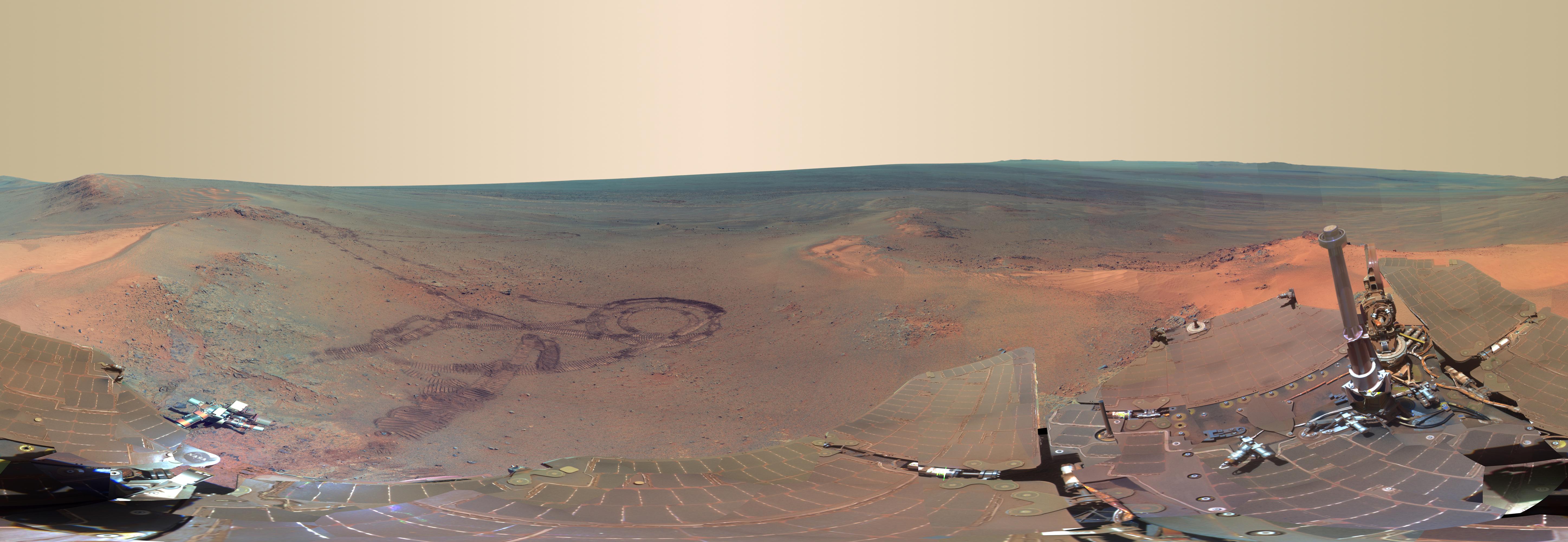
Today's Image of Mars comes from Mars Exploration Rover Opportunity during its fifth Martian winter. This image is a panorama of the rover's view from Greeley Haven during its winter stay at the location, between Sol 2811 (21 Dec 2011) and 2947 (8 May 2012) of its mission. The center of this image is looking North, while South is on both sides of the image. Imagine this image wrapped around you with both ends connected, so that you have a 360 degree view.


Center left in this image you can see the tracks left by MER Opportunity as it navigated through the area and up to Greeley Haven. The tracks have revealed that the bright soil we see over much of the surface is just a thin layer, under which lies darker soil. Future examinations of surface soil will likely require an examination of the top layer of dust and the underlying darker layer because the two layers are distinctly different.

In this image you can see the interior of Endeavour Crater on the right. On the left you can see bright wind blown deposits against an outcrop of Greeley Haven. North, northeast, and east of Greeley Haven  you can see even more bright deposits. At the center of the image is a bright patch called North Pole, which MER Opportunity examined in May 2012, as an investigation into bright wind-blown dust.

This panorama is a compilation of 817 different images taken by the rover's panoramic camera. I highly recommend you click on the image so you can see the high resolution version and zoom in on all the amazing features!


Mars Photo of the Day - Jan 25 2012

Today's Image of Mars shows Mars Rover Opportunity's magnificent view looking north from Greeley Haven, the rover's resting point for its fifth winter on Mars. This is just part of a 360 degree view that is being compiled by images from Opportunity.

In this image you can see the northern edge of Endeavour Crater's Cape York, which forms an ark across the upper half of the scene.You can also see features sculpted by wind at the front of this image. Opportunity will be monitoring the changes caused by wind throughout its stay at Greeley Haven in hopes that doing so will help scientists learn more about wind and the way it shapes the various features on Mars.

In addition to monitoring the wind, Opportunity will be conducting a radio-science investigation of the interior of Mars and inspecting the outcrops to determine their mineral composition and textures.

Clicking on this image will take you to the original high resolution image from NASA. [See their caption for this image]


Credit: NASA/JPL-Caltech/Cornell/Arizona State Univ.

Mars Photo of the Day - Jan 13 2012

Today we're going to take a look at 15 different images of Mars taken by the Mars Reconnaissance Orbiter's HiRISE camera. These images show the parachute and backshell of the six successful Mars Landers: Viking I, Viking 2, Mars Pathfinder, Spirit, Opportunity, and Phoenix

It is easy to spot these landers and their associated hardware because we know exactly where they landed. We still haven't been able to find the failed landers, Mars 2, Mars 3, Mars 6, Beagle 2, and Mars Polar Lander, despite extensive searching. Finding the failed landers is much harder because we don't know where they land and we have to guess according to their last known positions as they approached Mars.

When trying to identify a lander the easiest things to identify are the parachute and the large protective backshell. As you can see from most the of the below images, the parachute is the easiest thing to see. The lander itself is relatively small and hard to see. All but one (Mars 2) of the lost landers are believed to have deployed their parachute so they should theoretically be visible if in an area imaged by HiRISE.

Clicking on this image will take you to the original article from the Planetary Society about finding Mars landers.


Get Mars Rover Opportunity Images Sent to Your Phone

That's right! There's an app for that! Now you can browse the latest images from the surface of Mars on your phone! And it's FREE!

The new Mars Images app grabs images from Mars Exploration Rover Opportunity's latest transmission as soon as they become available. Mars Images also allows you to browse through old photos from Opportunity. The app was developed by Mark Powell, a computer scientist with NASA's Jet Propulsion Laboratory.

You can download the app for FREE on the iPhone/iPad and Android phones.

Below are some screenshots from the iPhone/iPad version (top) and the Android version (bottom). Clicking on these images will take you to their respective sites where you can download them for FREE.


Mars Photo of the Day - Jan 12 2012

Today's Image of Mars is of Mars Exploration Rover Opportunity's breathtaking view looking north from the top of Cape York. This image was compiled and colored by The Road to Endeavour's Stuart Atkinson from some of the original images taken by Opportunity.

This is just a taste of the 360 degree panoramic that the MER team has promised to come out with as Opportunity spends the winter at Greeley Haven. The next few months promise to be exciting as Opportunity will be sending back a ton of images showing magnificent views like this!

Clicking on this image will take you to the original, larger image from The Road to Endeavour. I highly recommend checking it out and reading Atkinson's post with this image.

Mars Photo of the Day - Jan 8 2012

Today's Image of Mars is of 'Greeley Haven,' the site for Mars Exploration Rover Opportunity's fifth winter resting point. Greeley Haven in near the northern tip of the Cape York segment of Endeavour Crater. 

Greeley Haven was selected by the MER team because of its interesting geological features and the fact that it lies on a North facing slope. Opportunity needs to spend the winter on a north facing slope in order to optimize its solar energy.

From this position Opportunity will take a 360° panorama of the surrounding area. The Mars rover will also study the terrain and material of Greeley Haven.

This image was taken on Sol 2793 of Opportunity's mission, which was on December 2 2011. Clicking on the image will take you to the original captioned image from NASA. 


Mars Photo of the Day - Dec 29 2011

Today's Image of Mars shows concave up features called 'festoons' on some rocks imaged by Mars Exploration Rover Opportunity. These geometric features, when found in sedimentary rocks like these, imply the presence of small, winding sand ripples that only form in the presence of water on Earth.

In short, these festoons are preserved remains of tiny sand dunes that formed long ago by ripples in shallow water on the surface of Mars. 

Clicking on this photo will take you to the NASA gallery where this image can be found and downloaded.


Mars Photo of the Day - Dec 22 2011

Today's Image of Mars shows what different stages of a solar eclipse by Phobos looks like on Mars. Phobos is the larger of two Martian Moons. These three images were taken by Mars Exploration Rover Opportunity on the 45th sol (Martian day) of its mission. 

Phobos is only 27km in diameter at its longest point, so as you can see it doesn't completely block out the Sun.

Clicking on the image will take you to the original NASA press release on these images from March 11 2004.


Mars Photo of the Day - Dec 19 2012

Today's Image of Mars shows Mars Exploration Rover Opportunity's discarded lander, the Challenger Memorial Station, at Meridiani Planum. This image is a mosaic of 12 images taken by the rover's panoramic camera on Sol 24 of Opportunity's mission. 

The mission is now approaching its 8 year anniversary (Jan 25 2012) since landing on Mars. The rover has continued operations much longer than the 90 day mission it was intended for. 

Clicking on this image will take you to the original high definition image from NASA.


To see updates on Mars Exploration Rover Opportunity I highly recommend reading Stuart Atkinson's blog on the rover, The Road to Endeavour.

Mars Photo of the Day - Dec 16 2011

Today's Image of Mars was taken by Mars Exploration Rover Opportunity shows a geological region of the rock outcrop at Meridiani Planum. This photo shows an area approximately 1.5cm across. This is one of the famous "blueberries" which are grey hematite concretions and evidence that water once existed on Mars.

This image was taken by Opportunity on Sol 28 of its mission, which was just a few weeks after it landed on Mars. Clicking on this image will take you to images and articles pointing to further evidence that water was once abundant on Mars. 

Mars Photo of the Day - Dec 7 2011

Today's Image of Mars is another view of Homestake, the vein recently examined by Mars Exploration Rover Opportunity on Mars. Today NASA announced that Homestake appears to be Gypsum or another form of calcium sulfate. This is further evidence that water once flowed on The Red Planet.

This photo links to the original full size image from MER Opportunity
Source: NASA/JPL/MER

To understand how NASA came to this conclusion I have taken an excerpt from their article on the matter.
The Homestake deposit, whether gypsum or another form of calcium sulfate, likely formed from water dissolving calcium out of volcanic rocks. The calcium combined with sulfur that was either leached from the rocks or introduced as volcanic gas, and it was deposited as calcium sulfate into an underground fracture that later became exposed at the surface.
The Mars Rover's Spirit and Opportunity have found evidence of water on Mars before, so what makes Homestake so special?

Homestake is more highly concentrated Calcium Sulfate than any previously examined on Mars, which leads scientists to believe that it may have been deposited by water that was less acidic than indicated in previous areas Opportunity has examined. Water that is closer to neutral would be more hospitable to life as we know it.

For more on Homestake I recommend you read the official NASA news release on the matter.

Mars Photo of the Day - Dec 1 2011

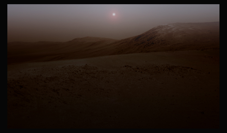
Today's Image of Mars is of a simulated sunrise on Mars taken from the vantage point Cape York. This image was created by Stuart Atkinson using an image taken by Mars Exploration Rover Opportunity. He then inserted the Sun and and sky effects. Atkinson has dubbed this "Endeavour Sunrise." While he claims it is not  accurate, I will venture to say it is about as accurate an interpretation as you're going to get. The only thing more accurate would be if Opportunity was sending back full-color images.


Clicking on this image will take you to Stuart Atkinson's post on The Road to Endeavour which contains this image. 


Mars Photo of the Day - Nov 24 2011

Today's Image of Mars is of part of Turkey Haven, the aptly named place that Mars Exploration Rover Opportunity will be spending the Thanksgiving weekend. Oppy will be studying the rocks in Turkey Haven for the weekend. I felt this was a fitting image for Thanksgiving Day, don'r you think?

There are a lot of interesting rocks and features in Turkey Haven and the microscopic imager is sure to return some great fascinating photos after the long weekend!

As with most images from Mars Exploration Rover Opportunity, this has been colored by Stuart Atkinson from The Road to Endeavour. Clicking on the image below will take you to the post on his blog where this image is from.


Mars Photo of the Day - Nov 19 2011

Today's Image of Mars is absolutely stunning. What you see below is Mars Exploration Rover Opportunity's view from the highest vantage point of Cape York. You need to click on this image and see the high resolution beauty of Mars. 

And who else could transform the black and white images sent from Opportunity into something so magnificent? Stuart Atkinson from The Road to Endeavour of course! He has some really awesome images, including a false color image of the one below. You really need to check out The Road to Endeavour post including this image and if you follow Opportunity at all you need to keep up with his blog.


Mars Photo of the Day - Nov 7 2011

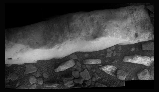
Today's Image of Mars is once again of Homestake, that mysterious vein Mars Exploration Rover Opportunity is currently inspecting. This was compiled by Stuart Atkinson from The Road to Endeavour from a collection of images taken by Opportunity's microscopic imager. 

The image shows that Homestead is weathered and covered with grooves. Homestead is denser than the surrounding material, making it more resistant to weathering. But just what is Homestead made of? 

While the MER team has not announced anything officially, Atkinson reports that many MER forums are abound with the theory that Homestead is made of the mineral magnesite. For more information on that particular mineral I suggest you highlight the the word "Magnesite" on my page; The Wikipedia page on Magnesite should pop up into a little window, telling you all you want to know about that mineral, and more! 

This image links to Atkinson's post with this image on The Road to Endeavour.


Mars Photo of the Day - Nov 4 2011

Today's Image of Mars is a color closeup of the mysterious vein called Homestake.  Mars Exploration Rover Opportunity has stopped to examine it en route to find a safe haven for the looming winter. The MER team is very interested in this protruding rock.

But of all the rocks on Mars, why this rock?

Well according to the MER principle investigator, Steve Squyres,  this rock is "different than anything from anything we've ever seen with either rover, a completely new thing on Mars, never seen anywhere. And we're pretty charged up about it." Now if you ask me, that is something to be excited about! And just look at how much it stands out!

I  promise that I will keep you updated on all developments related to this vein!

Click on the image to see the article containing this image, as well as other amazing images of this vein enhanced by Stuart Atkinson from The Road to Endeavour. If you don's you'll really be missing out!

The image was colored and augmented by Stuart Atkinson from The Road to Endeavour. 


Mars Photo of the Day - Oct 30 2011

Today's Image of Mars is a panoramic of Victoria Crater as taken by Mars Exploration Rover Opportunity in 2006. This image is taken from the vantage point of Cape Verde and compiled from images taken over a period of three weeks, from Oct 16 2006 to Nov 2 2006. 

Click on the image to see the enlarged version (Trust me, you want to).
Source: NASA/JPL Mars Exploration Rover Opportunity

Mars Photo of the Day - Oct 27 2011

Today's Image of Mars once again comes from Stuart Atkinson at The Road to Endeavour. It shows a realistically colored image of a rock Mars Exploration Rover recently passed called "New Consort." I'm not sure where the MER team came up with that name, but I've long since given up trying to guess. The original black and white image were sent back today, but it was taken as Opportunity passed by the rock roughly two days ago. 

Clicking on this image will take you to the post from The Road to Endeavour where he discusses the image (and some others). I can't impress enough on all of you how amazing Atkinson is. He brings the raw images from Opportunity to life and his commentary makes you feel like you are right there alongside the Mars Rover. I highly recommend you click this image then subscribe to his blog.


Mars Photo of the Day - Oct 18 2011

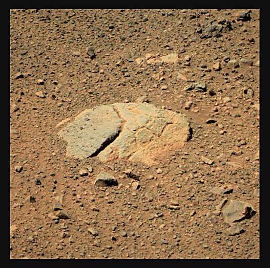
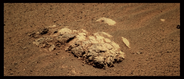
Today's Image of Mars is of a rock dubbed Sheba by the Mars Exploration Rover Opportunity team. Sheba is in the area where the highest levels of phyllosilicates have been detected from orbit. 

This is just one of many intriguing science targets Opportunity has passed by in its search to find a north facing slope where the rover will wait out the oncoming Martian winter. 

This image was colored by Stuart Atkinson from The Road to Endeavour and it links to the article containing this image.