Google+ Mars Travel: Inverted Riverbed
Showing posts with label Inverted Riverbed. Show all posts

Inverted Features on Mars

Imagine a river or lake on Earth. What would it look like if you took all the water out? Something like this:


Dry Riverbed in the Himalayas
On Earth, when a riverbed dries out it leaves a depression, or indentation in the Earth.


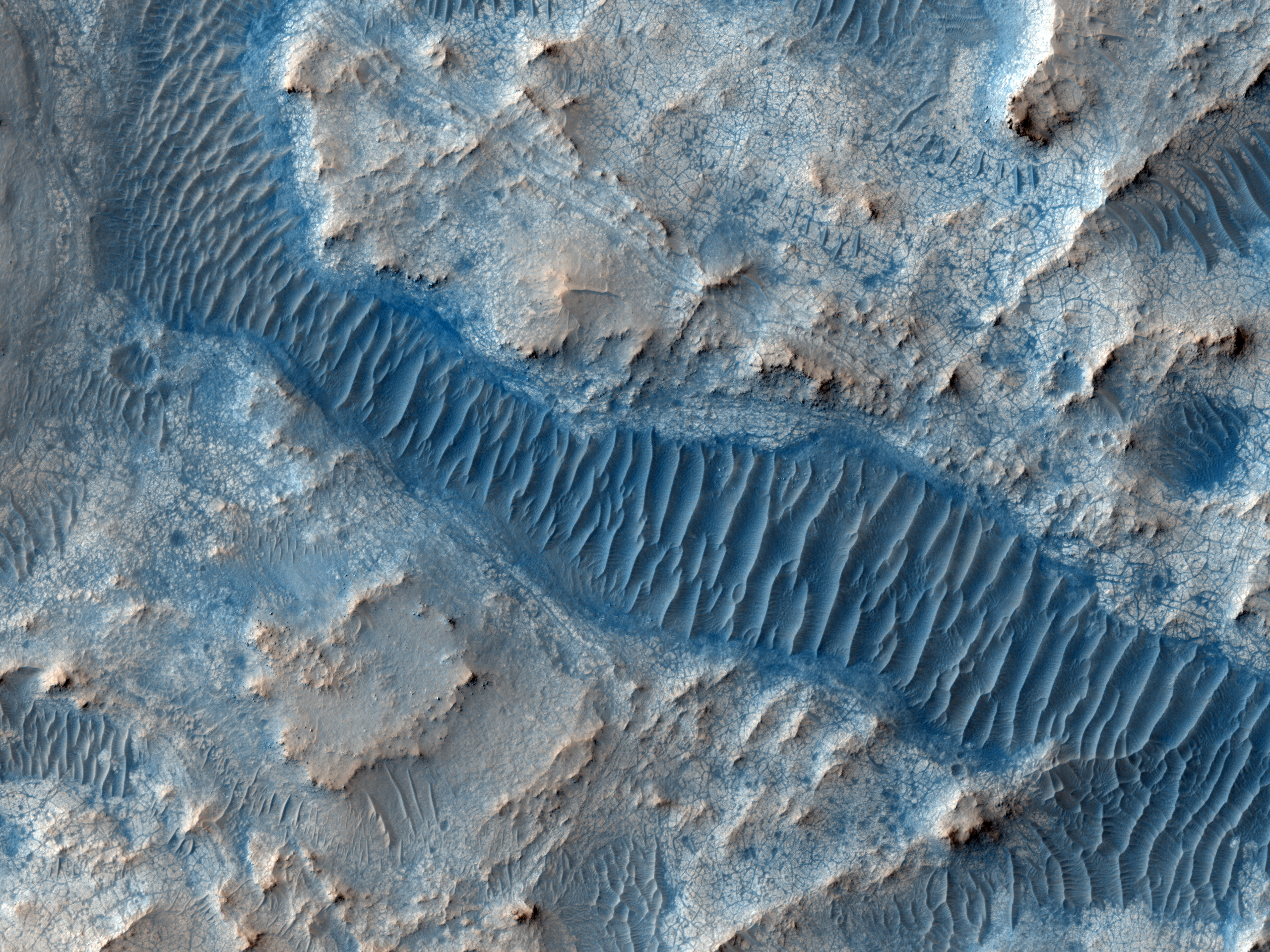
So then why on Mars are riverbeds and lakes inverted, or raised features, like in the below image of Gorgonum Basin?


http://www.uahirise.org/ESP_045344_1420
Gorgonum Basin. Credit: HiRISE (Click through for HiRISE captioned image)
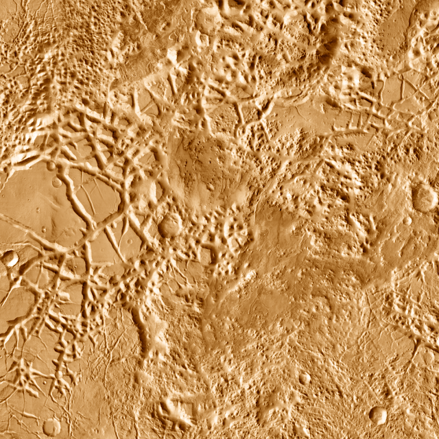
or Iani Chaos?


http://www.marstravel.org/2012/01/mars-photo-of-day-jan-16-2012.html
Iani Chaos. Credit: THEMIS (Click through to post on this image)


It all comes down to erosion. The weight of the water condenses and compacts the sediment beneath it, making it much harder and more resistant to wear from erosion. Thus, over the course of millions (and sometimes billions) of years, the ground surrounding the river bed gets eroded much more rapidly than the riverbed itself. This results in the inverted features that you see on Mars today.

Mars Photo of the Day - June 6 2012

Today's Image of Mars is a picturesque example of what became of the rivers on Mars and the effects those ancient bodies of water had on the surface. You can see in this image that much of the terrain is composed of light and moderately toned layered material. The cratered, lower elevation areas tend to be darker.

Clicking on this image will take you to the original high resolution one from HiRISE. [See their caption]

Mars Photo of the Day - Feb 2 2012

Today's Image of Mars was taken on Jan 14 2004 and was one of the first returned from the European Space Agency's Mars Express orbiter. The image shows a stretch of Valles Marineris, considered to be the Grand Canyon of Mars. 

The raised surfaces seen in this image are likely inverted riverbeds formed when the sediment deposited by rivers is harder than the surrounding terrain. Over billions of years erosion wore down the surrounding terrain, but because the riverbeds were more resistant to erosion they were reduced much less, thus creating the inverted features you see in the image below.

Clicking on this image will take you to the original high resolution image from Mars Express. [See the ESA article on this image]


Mars Photo of the Day - Jan 16 2012

Today's Image of Mars once again shows Iani Chaos, but this time we can see all the intricate features  created by the massive amount of water that once passed through the area. Iani Chaos was the source for the large outflow channel, Ares Valles after geologic faults ruptured an enormous reservoir of ground water, causing it to flood the surface.

Two Mars orbiters (Mars Global Surveyor and Mars Express) have found mineralogical evidence that there was once an abundance of water in Iani Chaos, lending credence to the idea that the features below were formed by water. The two Mars orbiters found hematite and gypsum in the area, two minerals that are only known to be formed in the presence of an abundance of water.

But how did all these features form?

Looking at the image you can see many web-like features created by what look like inverted riverbeds. Once active rivers on Mars deposited sediments, which were more wear-resistant than the surrounding terrain. When Mars dried up these sediments remained. Over billions of years the wind on Mars eroded the landscape, but the hardened sediments were harder than the surrounding terrain so they became less eroded, thus the reason you see this web of features.

But where did these rivers come from?

When geologic faults ruptured an underground reservoir, millions of tons water poured out onto the surface. The water took the easiest way out, following natural features and creating what we see here today. 

You can see in the bottom right of this image that the terrain is about as high as the inverted riverbeds we see elsewhere. I think we can safely assume from this that there was an enormous presence of water at the bottom right of this image, which drained through the interlocking riverbeds we see below. While this is just an educated guess, these same features are common on Earth, where great lakes and seas have channels and rivers feeding into and out of them.

 Clicking on this image will show the larger size. To see the THEMIS article this image came from
Source: THEMIS

Mars Photo of the Day - Dec 9 2012

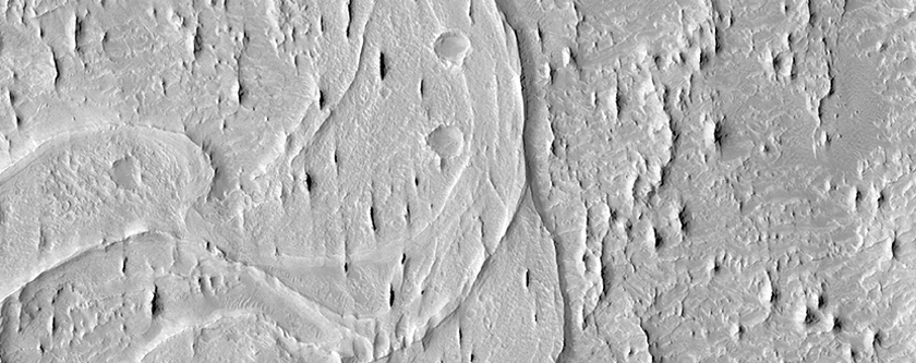
Today's Image of Mars shows an inverted, winding, riverbed surrounded by features called yardangs

Yardangs are created when the primary form of erosion is wind. They are easy to identify as they have multiple sharp ridges that are oriented in a similar way: a result of wind erosion over millions of years. 

But why is the riverbed raised? Shouldn't it be carved into the surface?

When the river was flowing it deposited layer after layer of sediments, which were harder than the surrounding terrain. Since the river dried up the whole area has spent millions of years being eroded by wind. Because the sediments deposited by the river bed were harder than the surrounding terrain they were eroded much less than the rest of the surface, thus the reason the river bed is inverted.

Today's image was taken by HiRISE. Clicking on the image will take you to the original captioned image from them!