Google+ Mars Travel: May 2012

Mars Photo of the Day - May 31 2012

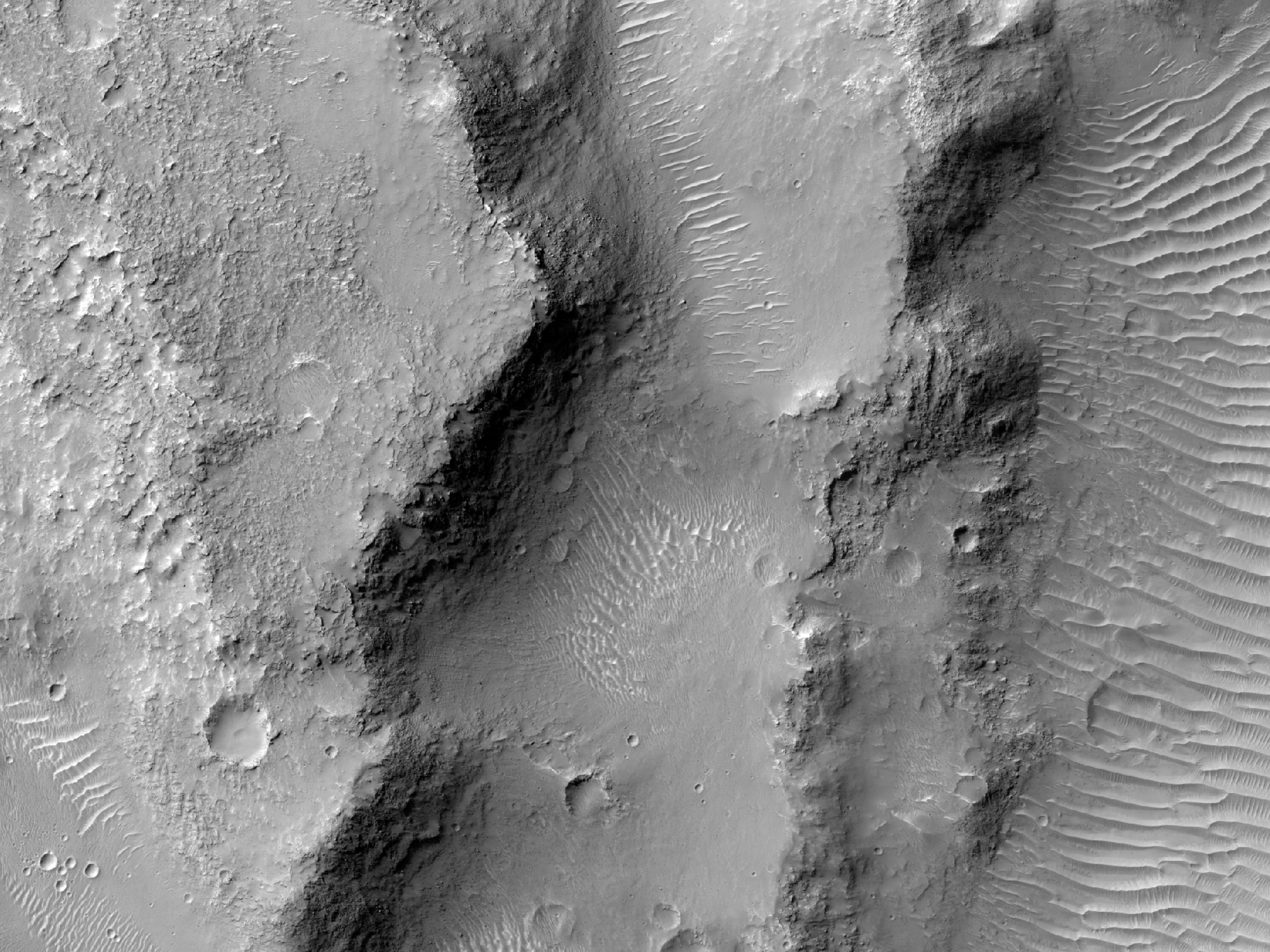
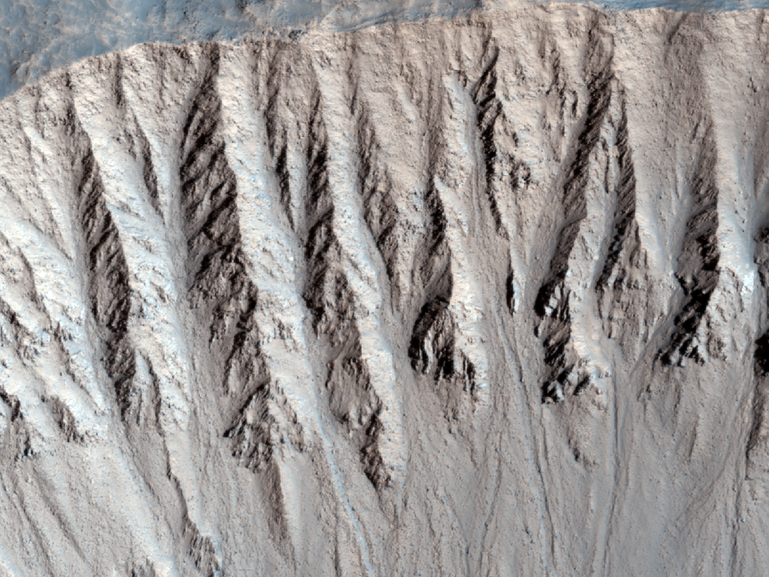
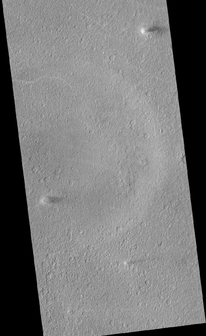
Today's Image of Mars shows a location near the mouth of Morava Valles, as imaged by HiRISE. Morava Valles is an outflow channel that scientists speculate was formed when Ladon Basin overflowed and sent water rushing toward the chaotic terrain to the north of Ares Valles.

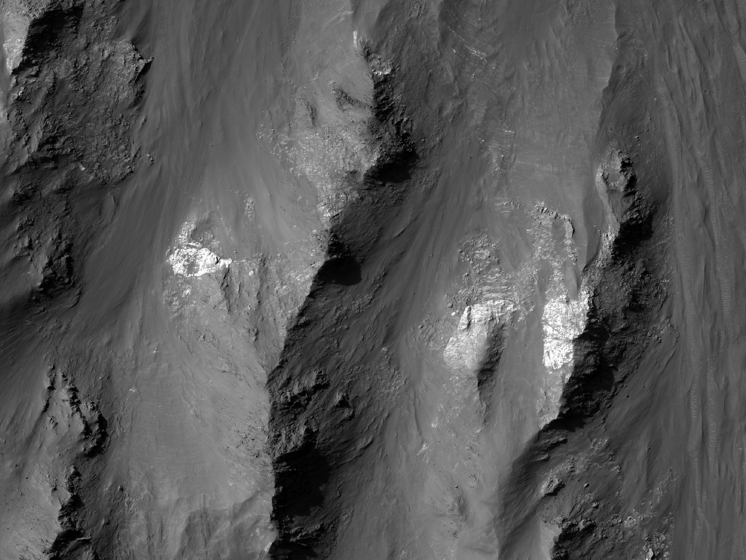
There are other valleys/riverbeds that seem to emerge from Ladon Basin. Something they all have in common are the layers exposed on the surface. As you can see in the image below these layers can be very distinct. Further study of these layered deposits will help scientists to verify that they were deposited by flowing water. Scientists may also be able to determine when the layers began getting deposited and when they stopped being formed. Determining this will allow us to get a better idea of when water was present on Mars, and how long it lasted on the surface.

Click on this image to see the original high resolution image from HiRISE.


Mars Photo of the Day - May 30 2012

Today's Image of Mars shows different minerals exposed along a slope in Coprates Chasma, as imaged by HiRISE. The slope is on the left in this image, while the floor of Coprates Chasma is on the right. The brighter material has been exposed over millions of years of erosion and likely represents minerals that are older than the overlying terrain.

It appears that these minerals were deposited at a time when water or ice was abundant. We can tell this by the composition and layering of the material. The material seems to be of a sedimentary nature and it contains layers that are oftentimes seen in materials deposited by water.

Clicking on this image will take you to the original high resolution image from HiRISE. [See the original HiRISE caption]


Mars Photo of the Day - May 29 2012

Today's Image of Mars shows craters that have expanded due to the high impact temperatures sublimating the surrounding icy terrain. As you can see there are craters surrounded by wider, shallower depressions. These depressions surrounding the impact craters formed when the heat from impact made the carbon dioxide ice surrounding it turn directly into water vapor.

The depressions are elongated in the direction the meteorite struck because the impact created heated material that projected itself forward, which sublimated the ice in that direction. Imagine throwing a golf ball into a bowl of ice cream. If the ball comes in at an angle some of the ice cream will be uplifted and thrown forward, on top of other pudding. When this happens at a high enough velocity the friction between the surface of Mars and the impacting meteorite heats up the terrain it touches and launches it forward. The heat was enough that it sublimated the carbon dioxide ice and created the depression that you see oriented in the direction of the impact.

Clicking on this image will take you to the original high resolution image from HiRISE. [See their original caption for the image]


Mars Photo of the Day - May 21 2012

Today's Image of Mars shows streamlined features in Cerberus Fossae, as taken by HiRISE. These are indicative that water once flowed across the surface of Mars and eroded islands into what we see below, most particularly at the upper left of the image. Just imagine a huge wall of water washing over an island. Now imagine this happening constantly. It's going to flatten that island out, smashing it in the direction of the water flow. That's what happened in the image below.

These features also exist on Mercury and the Moon, where they were formed by lava, but scientists believe the case is different on Mars. They believe that on Mars these streamlined features were created by flowing water, which then evaporated or went underground. These streamlined features occur in areas where scientists believe large channels of water existed. In almost all instances the features have a layer of lava overlying them, which lends credence to the theory that the features were eroded by water, and covered by subsequent lava flows.

Observations like the one below will help scientists to prove their hypothesis that lava covered the features eroded by water. Click on the image to see the original high resolution image from HiRISE. [See their original caption]


Live Stream: SpaceX Dragon Spacecraft Launch to International Space Station

SpaceX Falcon 9 launch was successful! See this SpaceRef article for further details!

Edit: Countdown reached 0, but the mission was aborted! A high chamber pressure reading was detected on Engine Number 5 of the first stage. Sometimes when a Falcon 9 experiences this it is a simple fix, but because the clock was at one second before discovery the rocket will have to go through the startup sequence again and all systems need to be rechecked prior.

New Launch Date and Time: 3:44:34 a.m. EDT, Tuesday 22 May 2012.

Watch live coverage of the SpaceX Dragon spacecraft on its way to the International Space Station. The Dragon capsule will launch aboard a Falcon 9 rocket at 0455 EST on May 19 2012. The video will play automatically at least one hour before the new launch. This video is hosted by SpaceFlightNow.


For tweeted updates on SpaceX's historic mission.

Watch live streaming video from spaceflightnow at livestream.com


Should this mission succeed (and we hope it does!) it will be the first time a commercial spacecraft has docked with the ISS. This unprecedented mission will bring the United States one step closer to eliminating reliance on Russia for launch vehicles to the ISS.

Mission Patch
Credit: SpaceX

Mars Photo of the Day - May 17 2012

Today's Image of Mars shows the rim of an extremely recent impact crater in the Cydonia Colles Region, as taken by HiRISE. But how do we know that this is a recent impact crater?

An impact crater is deemed recent when it has a sharp rim, meaning that it is only lightly eroded. Generally crater rims undergo a process of erosion that wears away the sharpness of the rim. This occurs over hundreds of thousands, if not millions of years.

What does the term 'recent' mean?

The term recent is relative. In this case it is used in the geological sense, which means the crater could have formed tens of thousands of years ago or longer. The key is that it isn't as old and eroded as  Gale Crater or other ancient impact sites.

On Mars it can take a long time for features to change. Because there is no precipitation on present-day Mars, the wind is the only eroding element. This means that it takes a long time to wear down sharp crater rims, sometimes millions of years depending on the area.

Clicking on this image will take you to the original high resolution image from HiRISE. [See the original caption]


Mars Photo of the Day - May 16 2012

Today's Image of Mars shows a potential landing site for future missions to Mars west of Aeolis Planum, as imaged by HiRISE. Within this potential site we see numerous ridges with a general North-South orientation, which measure about 10 meters wide and 100 meters long. These ridges appear to have formed from wind, which suggests that the soil is made of fine grained sand and rocks, easily moved and oriented by the wind.

The crater that you see on the right of this image has been filled by soil, as have many other smaller crater you can see in different subimages. This implies that the bedrock underlying the top layer of windblown soil may be easily eroded. This could be the mos likely reason why there is so much sand able to form the ridges described above.

Clicking on this image will take you to the original high resolution image form HiRISE. 


Mars Photo of the Day - May 15 2012

Today's Image of Mars shows the Tharsis Trio (Arsia, Pavonis, and Ascraeus Mons) and Olympus Mons off to the Northwest. This image is very similar to one previously showcased by Mars Travel from the European Space Agency's Mars Express.

The Tharsis Trio are aligned in almost a perfect line pointing Northeast. Scientists speculate that all these volcanoes formed from a larger fracture/vent system that caused the three initial eruptions that created the Tharsis Trio. In other images you can see the vents pointing Northeast from Arsia Mons toward Pavonis and Ascraeus Mons, which lend credence to this theory. 

As far as I can tell this image was taken by Mars Odyssey Orbiter's THEMIS (please correct me if I'm wrong) Click on this image to see the original high resolution image.


Mars Photo of the Day - May 14 2012

Today's Image of Mars shows a perspective view of western Acidalia Planitia, a large basin in the northern lowlands. Acidalia Planitia is further evidence that Mars once contained vast quantities of water, which shaped the surface. 

You'll notice that most of this image appears to be in shadow, but that is not the case. The contrast is actually a variation in material. The darker sand is likely volcanic in origin, but the brighter material is actually bright dust that has overlain the darker material. 

We cannot be sure why only some of the area is covered by bright dust, but further analysis of the issue could help us to determine how quickly different features on Mars are overlain with new deposits. Understanding this will let us get a better idea of what lies just under a small layer of dust. If we reveal this, missions could be sent with the sole purpose of uplifting dust to see what lies beneath.

Clicking on this image will take you to the high resolution image from Mars Express. [See their article on Acidalia Planitia]


Weekend Feature: Gale Crater

Looking down on Mars we see Gale Crater as a crater among many craters, but even from this distant perspective Gale Crater is unique, special, and above all, intriguing. In the image below we can spot the 150km in diameter Gale Crater because of its massive central uplift, Mount Sharp, which rises 5.5 km above the northern crater floor and 4.5 km above the southern crater floor. It is Mount Sharp that makes Gale Crater so intriguing and worthy of future study.


Mount Sharp's base is thought to be at least 2 billion years old. It is comprised of clays and sulfates, two materials that are only known to form in the presence of water. The layers directly on top of those are comprised primarily of sulfates, with very few clays, which implies that they were formed in an environment where Mars was becoming drier and water was evaporating. See the next image for an idea of what these intriguing layers look like.

Mars Photo of the Day - May 9 2012

Today's Image of Mars shows frosted ground in the Southern Hemisphere of Mars during late fall, as imaged by HiRISE. The frost in this image is primarily carbon dioxide frost that began to accumulate as average temperatures dropped. Most of the frost is carbon dioxide frost because the Martian atmosphere is primarily carbon dioxide, which condenses onto the surface, not like the nitrogen that makes up most of the Earth's atmosphere and remains vapor at all Earthly temperatures. 

In this image the frost is blueish and primarily on south-facing slopes. The slopes facing north receive more sunlight so they contain less frost and appear red. During the winter months the frost will accumulate more heavily as the Sun becomes dimmer and less heat reaches Mars. Come spring the frost will sublimate until the next fall, and thus is the cycle on much of Mars. 

Clicking on this image will take you to the original high resolution image from HiRISE. [See the HiRISE caption for this image]


Mars Photo of the Day - May 8 2012

Today's Image of Mars shows a potential landing site for future missions to Mars in Trouvelot Crater. Trouvelot Crater is 154.7km in diameter and located in Oxia Palus Quadrangle, which is known for an abundance of chaos terrain, like Aram Chaos, and numerous outflow channels, most prominently Ares Valles.

Trouvelot Crater is being considered as a possible landing site for the the 2018 joint ESA-Roscosmos ExoMars Rover. One of the features that intrigues scientists are the sedimentary deposits on the crater floor, that many believe could only have been deposited by an abundance of water. On the ground study of these sediments would be able to determine when and how long there was water on the surface and could even provide insight as to where the water went.

Click on this image to see all the other potential landing sites for the ExoMars Rover showcased by Mars Travel.

Credit: HiRISE

Weekend Feature: Arsia Mons

Arsia Mons measures nearly 16km (12mi) high and over 435km (270mi) wide, with a caldera (opening) measuring 110km (72mi) in diameter It is the southernmost of the Tharsis Trio, which also consists of Pavonis Mons to the north and Ascraeus Mons to the north of that.

While Arsia Mons may be larger than any volcano on Earth, it pales in comparison to the largest volcano yet discovered in the solar system, Olympus Mons, which measures 22km (16mi) high. Coincidentally Olympus Mons is relatively close to the Tharsis Trio (right).

These volcanoes lie in the Tharsis Quadrangle on Mars, which contains an abundance of volcanoes. The region is thought to have been volcanically active as recently as 100-250 million years ago, which is relatively recent in geological terms.Scientists believe that the abundance of volcanoes in this region had an astronomical impact on the climate of Mars because the carbon dioxide and water vapor emitted from them would have been enough to create an atmosphere thicker than that on Earth!

This means that the environment we currently see on Mars may be drastically different than what it used to be! The Tharsis volcanoes would have had a direct impact on that, so determining how long ago they were active will help scientists to determine at which point the Martian climate changed!

Mars Photo of the Day - May 3 2012

Today's Image of Mars shows ancient hills in Phlegra Dorsa surrounded, and sometimes overwhelmed by flows that came out of Cerberus Fossae. The flows were made up of mud or lava flows, and maybe a combination of both.

Flow after flow came out of the fracture in Mars called Cerberus Fossae, each one building on the previous, until eventually some of the flows got high enough that they covered portions of the ancient hills. Should we send a rover down to the area surrounding these hills we could gain valuable insight about the contents of these flows and the time during which they were released from Cerberus Fossae. If we understand these two things we might be able to determine what triggered the cataclysmic releases, which could help us to understand if something similar could happen on present-day Mars.

Clicking on this image will take you to the original high resolution image from HiRISE. [See their caption for the image]


Mars Photo of the Day - May 2 2012

Today's Image of Mars show three distinct dust devils in North Amazonis Planitia, as imaged by HiRISE. You can also see lighter paths along which dust devils have passed previously. This is because when dust devils pass over the dust laden ground they pick up that darker dust and expose the lighter terrain below. In areas with lighter dust covering darker terrain, just the opposite effects occur.

Click on this image to see a captioned subimage of this one from HIRISE.


Mars Photo of the Day - May 1 2012

Today's Image of Mars shows how the Tharsis Trio (Arsia, Pavonis, and Ascraeus Mons) pale in comparison to Olympus Mons, the largest known volcano in the solar system. Of the Tharsis trio, Arsia Mons is the oldest and Ascraeus Mons is the youngest.

The Tharsis Quadrangle is full of volcanoes and is thought to have been volcanically active as recently as 100-250 million years ago, which is relatively recent in geological terms. It is thought that at one time the abundance of volcanoes in this region had an enormous impact on the climate of Mars.

Scientists have determined that the amount of carbon dioxide and water vapor released into the air by all the discovered Tharsis volcanoes would have been enough to create an atmosphere thicker than that currently on Earth. If this is the case the environment on Mars could have been completely different than what we see in images today.

Click on this image to see all images of Tharsis volcanoes showcased by Mars Travel. [See the Mars Express article with this image]

Credit: ESA/Mars Express