Google+ Mars Travel: March 2012

Mars Photo of the Day - Mar 31 2012

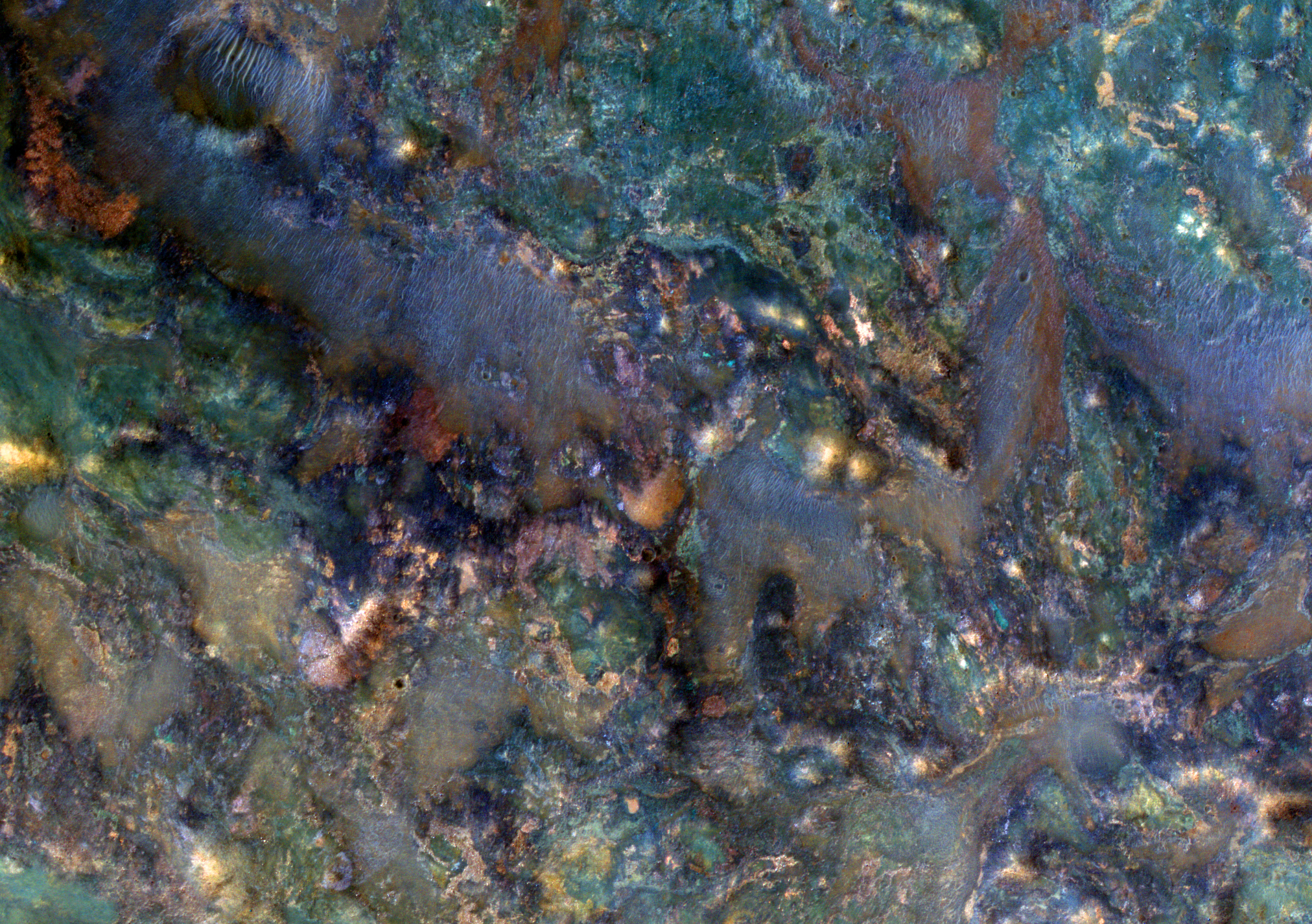
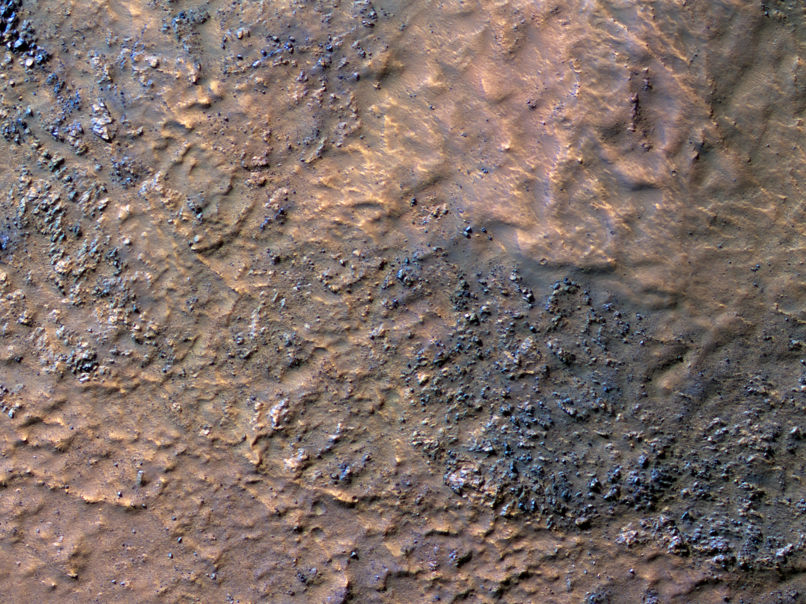
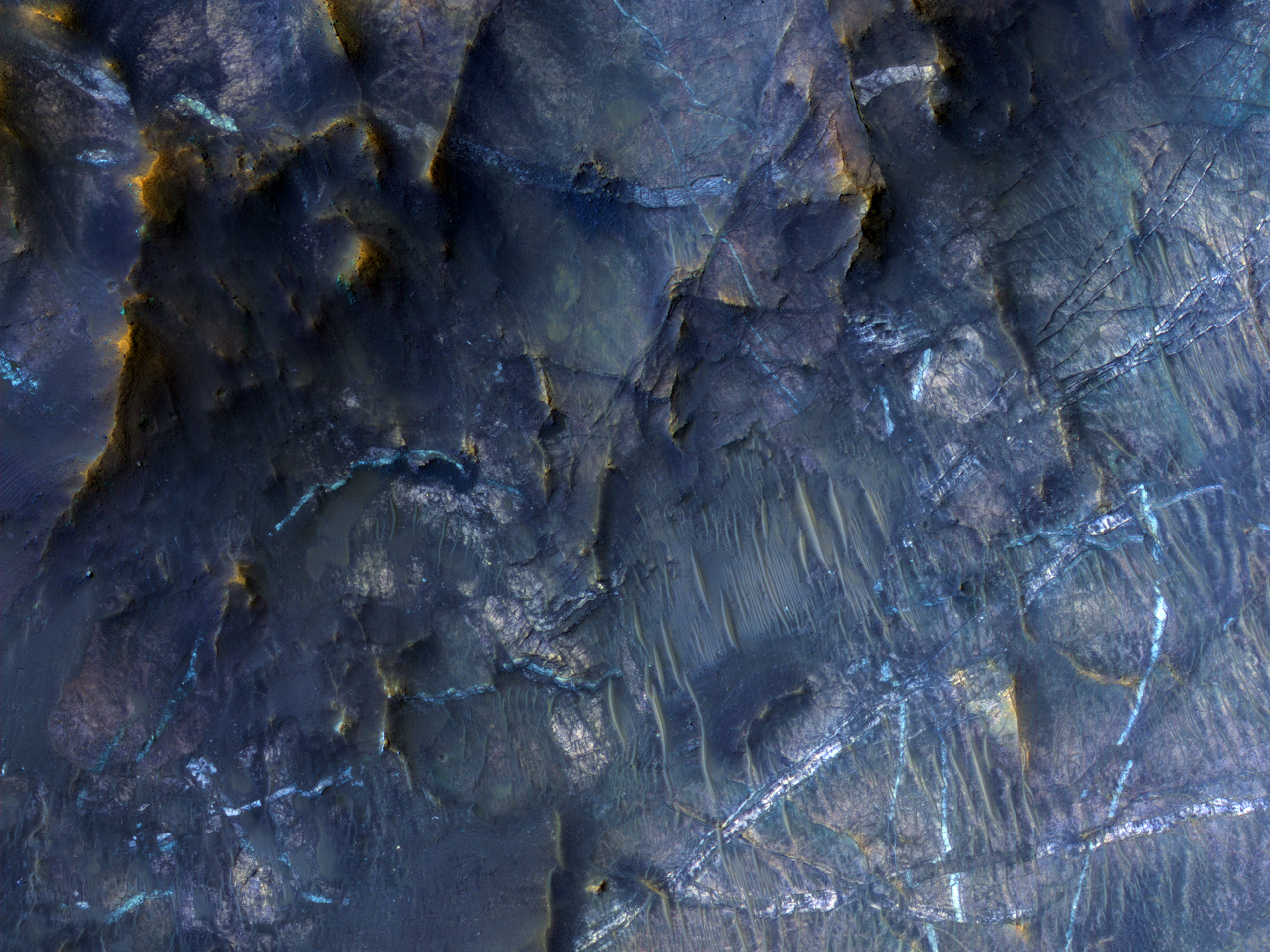
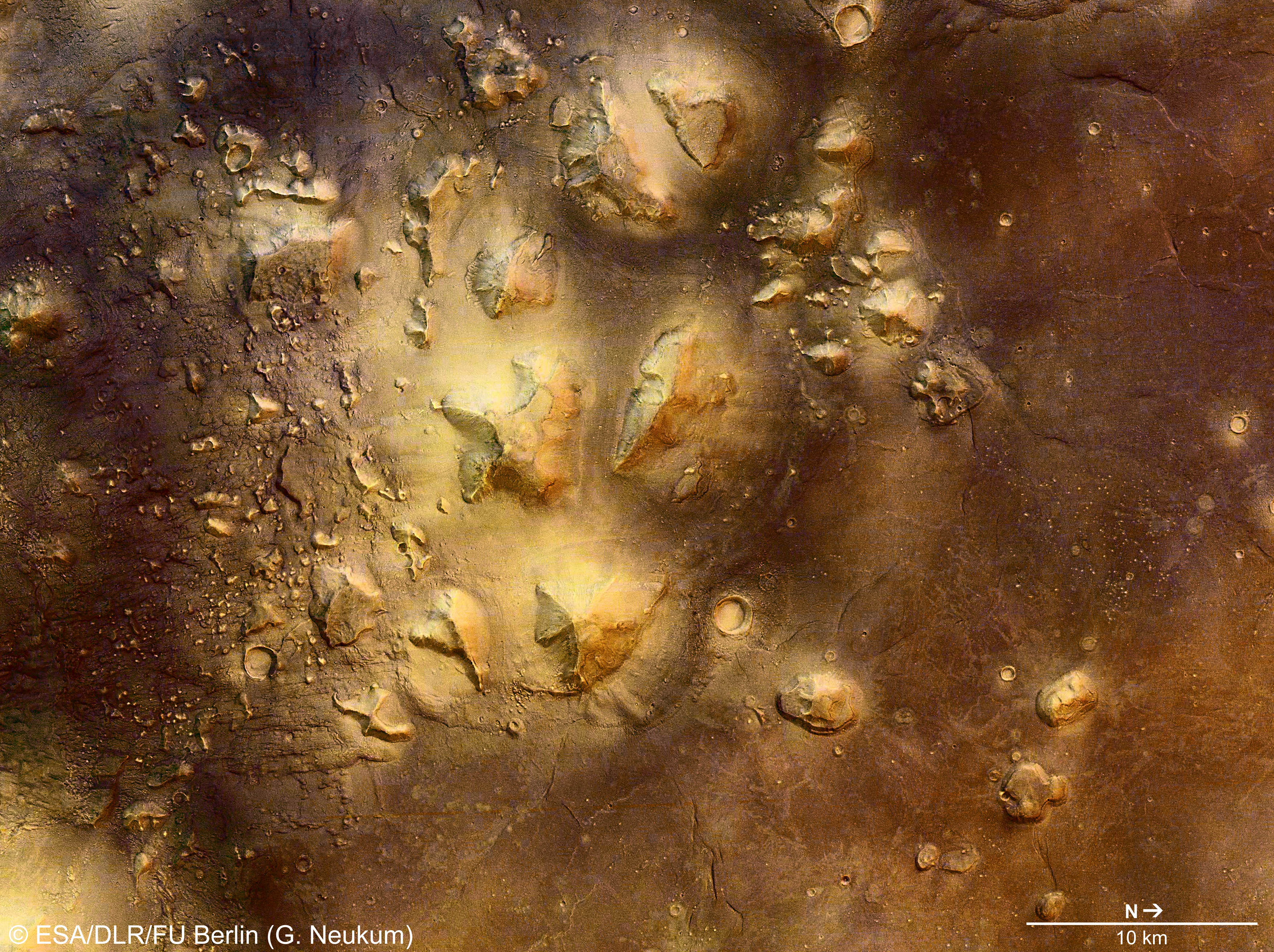
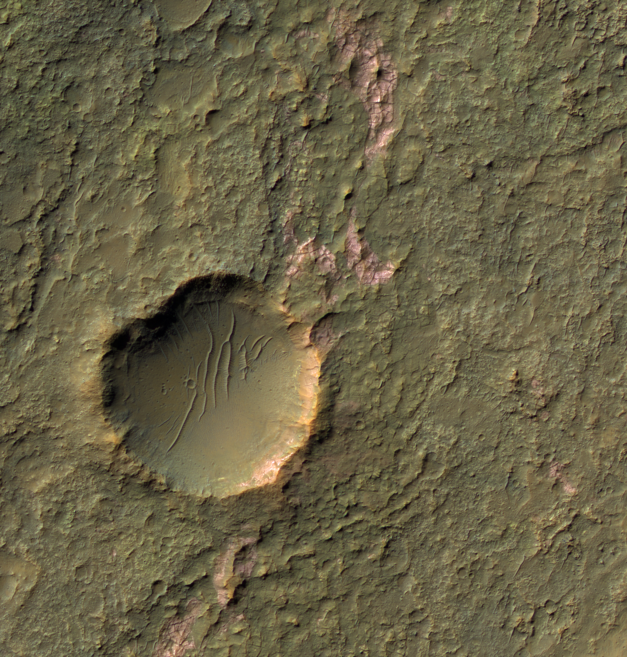
Today's Image of Mars shows some amazingly colorful minerals and rocks found in Nili Fossae by HiRISE. The stunning array of colored rocks are the ejecta from an impact that broke up and expelled already diverse types of rock, mixing them up even more. Each different color seen below is representative of a different mineral. 

There is a wealth of information about the past of the Martian climate that could be gathered by examining each of these minerals, so it may be that one day a mission is sent to Nili Fossae to do just that! Clicking on this image will take you to the original high resolution image from HiRISE. [See their caption for the image]


Mars Photo of the Day - Mar 30 2012

Today's Image of Mars comes from HiRISE shows a dune that lies close to an impact crater. This dune is special because it preserves the original bedform shapes of the sand dune, but lies over top of a previously eroded surface of sedimentary rock. 

Scientists are still attempting to find a dune that has been directly impacted by an asteroid, in hopes that it will help them better understand dunes and how they are formed.

Click on the image to view it in high resolution.  [See the original HiRISE caption for the image]


Mars Photo of the Day - Mar 29 2012

Today's Image of Mars shows the North Polar Region in late spring, as taken by HiRISE. Earlier in the year the ground was covered in ice, but now most of it has sublimated. The ice that remains is located in areas shadowed from the sun or in places where the ice built up and will take longer to sublimate. The easiest way to imagine those is by thinking of snow drifts on Earth, which may survive for weeks after all the other snow has disappeared.

Clicking on this image will take you to the original captioned and larger image from HiRISE.


Mars Photo of the Day - Mar 27 2012

Today's Image of Mars comes from THEMIS shows some very intricate chaotic terrain in Hydraotes Chaos. Chaotic terrain is typically made up of valleys punctured with numerous mesas and hills, as well as occasional pits. These features usually combine in a way that makes them seem patterned. The terrain in the center resembles a spiderweb, with many interlocking features.

Hydraotes Chaos measures about 300km from East to West and 350km from North to South and lies in a valley leading northeast out of Ganges Chasma to the east of Valles Marineris. The channels in this image were created by catastrophic flooding of the region approximately 2-3.8 billion years ago.

This dating was determined by counting craters on the surface, a method used by scientists to determine the relative age of terrain on extraterrestial bodies. The idea is that the more craters there are, the older the feature is since a recent feature is less likely to have been impacted by as many asteroids.

This image is so small because if I make it any bigger it will take forever to load. To see the original, huge, high resolution image, just click on it. [See the original article on Hydraotes Chaos]


Mars Photo of the Day - Mar 26 2012

Today's Images of Mars come from HiRISE and show two avalanches in the North Polar Region of Mars! The HiRISE team was kind of enough to outline all of them in their collection of images from 2008. The left images show the context for the avalanche and outlines what area the image to the right will show. 

The dust clouds produced by the avalanches can be huge! The one shown in the top image measured about 180m in diameter and extends around 190m from the base of the cliff. The shadows to the lower left of each image indicate that these are dust clouds and not just a strange feature on the surface.

The particular cliff imaged here is over 700m tall and has slopes of over 60 degrees in some areas. The top left of these images shows the carbon dioxide frost that still covered the top of the scarps.

It is important that we learn how and why these geological processes work so that we can get an accurate picture of how Mars has evolved and what it looked like in the past. If we better understand the past environment on Mars we can better determine if Mars was once a planet more hospitable to life and we can use that information to determine what the environment on Mars is now and will become.

Clicking on these images will take you to the original high resolution images from HiRISE. [See their caption for the images]


Mars Photo of the Day - Mar 25 2012

Today's Image of Mars was taken by HiRISE in an attempt to image ice covered dunes, but it turned out that area was slightly overcast!

Just like here on Earth there are clouds on Mars! These are fairly thin clouds, so we can still make out the ice covered dunes below. The clouds are likely made up of tiny carbon dioxide ice particles, but occasionally they can be made up of tiny water particles! Unfortunately that doesn't mean that it rains on Mars, but scientists have determined that it does snow! The only problem is that they have never seen the snow touch the ground, so it can't be easily used as water by future explorers!

Clicking on this image will take you to the original high resolution image from HiRISE. Check it out!


Mars Photo of the Day - Mar 23 2012

Today's Image of Mars shows boulders on the floor of Hellas Basin, as taken by Mars Reconnaissance Orbiter's HiRISE camera. Hellas basin is approximately 2300km in diameter and measures 7152m deep. While the source of the basin has not been confirmed, most scientists believe an enormous object must have impacted Mars sometime in it's early history.

Since that time there appears to have been some sort of glacial activity in the region, which scientists believe was responsible for depositing the crudely aligned boulders we see below. If you ask me they almost look like larger versions of the blueberries (grey hematite concretions) imaged by Mars Exploration Rover Opportunity, but of course they aren't!

Clicking on this image will take you to the orignial high resolution image from HiRISE!


Mars Photo of the Day - Mar 22 2012

Today's Image of Mars shows huge, bright mineral veins on top of the central uplift of a crater measuring 50km in diameter. The central uplift measures 5km wide and is made up of bedrock dredged up from deep under the surface. Mineral veins are formed when water flows through fractures, depositing minerals.

Heat from the impact that created this crater melted ice and created a hydrothermal system that may have been capable of supporting life! Other areas on Mars have also shown signs of previously going through hydrothermal activity, which gives hope that it was once habitable since two of the requirements for life as we know it are water and heat!

Mars Exploration Rover Opportunity recently discovered a small mineral vein called Tisdale


Mars Photo of the Day - Mar 20 2012

Today's Image of Mars shows frost in Utopia Planitia, as taken by the southwest facing Viking 2 lander on May 18 1979, approximately one Martian year (687 days) after the lander first imaged frost at the same spot. This thin layer of water-ice frost on Mars is thought to be only a couple thousandth's of a centimeter thick.

But how did the water-ice frost form? Scientists believe that dust particles throughout the Martian atmosphere pick up water particles , then when it gets cold enough for carbon dioxide to solidify some of it attaches to the dust and falls onto the surface.


Mars Photo of the Day - Mar 19 2012

Today's Images of Mars show simulated views of The Red Planet as seen from Earth every two hours between June 5, 2001 00:16 UTC and June 7, 2001 01:20 UTC. The simulations were created using images from Mars Global Surveyor. In order to fully appreciate these images you need to go to the original article because from there you can click on each individual globe and see an enlarged version of it.

To see the original article, simply click on the image below. You won't regret it!


Mars Photo of the Day - Mar 18 2012

Today's Image of Mars comes from THEMIS and shows a filled crater in the Tharsis Quadrangle. The only indication that this had once been a crater is what remains of the rim.

Before a crater becomes filled like one below the lava must break through the raised rim by pushing through gaps or weaknesses. Once it does this the lava pours into the crater, widening the gap in the rim and filling the crater. 

Clicking on the image will take you to the original high resolution version from THEMIS. 


Mars Photo of the Day - Mar 17 2012

Today's Image of Mars was taken by Mars Odyssey Orbiter's THEMIS and shows Galaxias Fossae, a 400km long fault cutting through Utopia Planitia. It is thought that Galaxias Fossae was created by lava that forced its way into a small vertical crack in the crust and expanded it. 

Galaxias Fossae - Clicking on this image will take you to the high resolution version from THEMIS. [Read their article]
The fault that originated Galaxias Fossae was likely created by the growth of the Elysium Volcanoes. Into that underground fault a small ribbon of molten rock forced it's way through, making the fault wider and bringing hot rock closer to the surface. That hot rock then encountered ground that was saturated with water and ice. The hot rock caused the ice to melt, which made the ground collapse.

Mars Photo of the Day - Mar 16 2012

Today's Image of Mars shows what was once an island in the middle of a Maja Valles,  a large sea on Mars, as taken by THEMIS aboard the Mars Odyssey Orbiter. The valley was created by a huge torrent of water likely released from a ruptured underground aquifer. If you can imagine, the water came rushing into the area, pushing everything in it's path aside and leaving the relatively smooth surface we see below.

The small island we see below was terrain raised high enough above the water that it wasn't covered. We can see that at some point this island may have been hit by an asteroid near it's bottom tip. If the asteroid hit while there was still water present that would explain why there are no visible remnants of the impact anywhere else but on the island. 

Clicking on this image will take you to the original high resolution image from THEMIS.


Mars Photo of the Day - Mar 14 2012

Today's Image of Mars is an amazing shot from Mars Express of Ceraunius Tholus (left) and Uranius Tholus (right). Ceraunius Tholus is 130km in diameter and 5.5km high, while Uranius Tholus has a diameter of 62km and a height of 4.5km.

Both Ceraunius and Uranius Tholus are located in the Tharsis Quadrangle of Mars, which was once a hotbed for volcanic activity on Mars. Clicking on this image will take you to the high resolution version. [See another image of Ceraunius Tholus and Uranius Tholus showcased by Mars Travel]


Mars Photo of the Day - Mar 13 2012

Today's Image of Mars shows mesas (flat topped hills or mountains) in the Cydonia region, as taken by Mars Express. One of the more prominent mesa's in this image can be seen in the far lower right. It became famous as the Face on Mars because Viking 1 Orbiter took an image of it that made it look like a human face. This created significant controversy, with conspiracy theorists claiming it was placed there by another species as a sign to humanity.

It turns out the reason why the rock looks like a face is much more mundane. It just happens that the time and angle Viking 1 took the image resulted in the mesa's features being lit in such a way that it resembled a human face. Subsequent images of the face on Mars (including this one) were taken with other orbiters and showed that it was nothing more than coincidence that the Viking 1 image made it look like a face.

As you can see in this image, the face on Mars is simply an interesting looking mesa, not a sign from another species, but despite all the evidence provided since the original Viking 1 image, conspiracy theorists continue to claim cover up. Sometimes people just can't be satisfied with reality I guess. 

I recommend clicking on this image so you can see the high resolution version and zoom in on the figure known as the face on Mars.


Mars Photo of the Day - Mar 12 2012

Today's Images of Mars show the largest Martian moon, Phobos making a rare transit past Jupiter in the night sky. Mars Express' high resolution stereo camera (HRSC) performed a special maneuver on June 1 2011 to capture the rare alignment, ensuring that it focused on Jupiter during the Phobo's transit.

Knowing the precise moment that Phobos passed in front of Jupiter, scientists will be able to improve their knowledge about the orbit of Mars' largest moon. Clicking on this image will take you to the Mars Express article on the transit.


Mars Photo of the Day - Mar 11 2012

Today's Image of Mars is a perspective view of Echus Chasma as taken by the High Resolution Stereo Camera (HRSC) aboard Mars Express. Located in Lunae Planum and measuring 100km long and 10km wide, Echus Chasma is one of the largest sources of water on Mars. 

The 4000m deep trough is thought to be the source for water that carved Kasei Valles, a 1780 km (1100 mi) long set of flood carved channels on Mars. 

Clicking on this image will take you to the original high resolution image from Mars Express. [See their article on Echus Chasma]


Mars Photo of the Day - March 10 2012

Today's Image of Mars comes from HiRISE and shows icy flows inside in the inner slope of a Hellas Basin impact crater. HiRISE took this image when there was very little light illumination from the sun. This low illumination enhances some subtle features in the Martian terrain and makes for an extremely dramatic image.

Mars Reconnaissance Orbiter has confirmed that other flows like this one in the region are are made up of ice. Icy flows like the one below could one day be used as a source of fuel and/or water for future missions to Mars.

Clicking on this image will take you to the original high resolution image from HiRISE. [See their caption for the image]


Mars Photo of the Day - Mar 9 2012

Today's Image of Mars comes from HiRISE and shows layers of water deposited sediment near the western rim of a large ancient crater. The layers seen below have a morphology similar to that seen elsewhere on Mars where channels have emerged into craters, creating alluvial fans.

In this case scientists cannot find obvious signs of a channel, but believe that the deposits left behind have been erased by wind erosion and other factors.

Clicking on this image will take you to the original high resolution image from HiRISE. [See their caption for the image]


Mars Photo of the Day - Mar 8 2012

Today's Image of Mars comes from HiRISE and shows the snaking shadow of a huge dust devil in Amazonis Planitia. The length of this shadow indicates that this particular dust devil is approximately 800m (half a mile) in height.

The reason that it is so serpentine is that at about 250m above the surface a westerly breeze pushed the top of the dust devil to the east. This particular dust devil is about 30m in diameter.

What is extraordinary about this dust devil is that it formed during a time of year when Mars is furthest from the Sun. Just as on Earth, the Sun plays a large role in the winds on Mars, but it seems that even when Mars is further away from the Sun, it still has numerous dust devils!

Clicking on this image will take you to the original, captioned image from HiRISE, from where you can view the high resolution images!


Mars Photo of the Day - Mar 7 2012

Today's Image of Mars is a dramatic example of a crater's slope streaks, as taken by HiRISE. Slope streaks often form in craters when dust and small rocks tumble down the side, but it isn't very often that we see a crater exhibiting so many well preserved streaks around its entire circumference.

Clicking on the image will take you to the original high resolution image from HiRISE. When you check it out you will see that the slope streaks are of varying shades, which indicates that the crater went through numerous episodes of streak formation.


Mars Photo of the Day - Mar 6 2012

Today's Image of Mars comes from HiRISE shows one of many recent impact craters that have revealed ice just below the Martian surface. This particular crater is about 6m in diameter and located in Mars' northern hemisphere, though it doesn't lie as far north as most observed craters exposing ice. This implies that ice may lie just below the surface much further south than previously assumed. Scientists speculate that the crater formed between April 2004 and January 2010.

Ice just below the surface could be used by future manned missions to Mars as a source of water, helping to sustain the crews for a longer duration without requiring as much cargo leaving from Earth. The ice could also serve as an environment for extreme life on Mars, since most life requires some sort of water. 

Clicking on this image will take you to the Space.com article about it. 


Mars Photo of the Day - Mar 5 2012

Today's Image of Mars shows a segment of Olympica Fossae, as taken by HiRISE.

Olympica Fossae is a 420km long set of troughs, or fossae, in the Tharsis Quadrangle on Mars. Fossae are created when the crust stretches and fractures along two parallel faults. When this happens the area between the two faults sinks down and forms a trough.

Scientists speculate that at one point in the Martian past the troughs of Olympica Fossae served as outflow channels, redirecting floods of water, while at another point they served as channels for lava. This is possible because Mars has experienced many different climates over the past few billion years.

Because HiRISE has yet to caption this image, clicking on it will take you to a map of Tharsis Quadrangle showcased by Mars Travel.


Mars Photo of the Day - Mar 4 2012

Today's Image of Mars comes from Mars Express and shows part of Syrtis Major, an area that once experienced intense volcanic activity. Syrtis Major is so large (1300 x 1500 km) that it can be spotted from Earth with even small telescopes.

By examining the number and size of craters in Syrtis Major, scientists have been able to determine that it is approximately 3 billion years old. New images of Syrtis Major show numerous lava flows that covered much of the original, ancient terrain, but the lava flows were forced around high, steep buttes, or isolated hills that could not be entirely engulfed by the lava flow. 

Clicking on this image will take you to the original high resolution image from the ESA, but I highly recommend checking out their article on Syrtis Planum.


Mars Photo of the Day - Mar 3 2012

Today's Image of Mars was taken by HiRISE and shows a channel-like formation with numerous branches being interrupted by a crater. The feature has a distinctive pink color, and retains a warm temperature at night, which suggests that it is exposed bedrock and not fine-grained materials.

The pink patches in the image below are similar in color, morphology, and geologic setting to larger deposits on Mars that are thought to consist of chloride salts like Sodium Chloride, Magnesium Chloride, and Potassium Chloride. The important thing to note about the presence of chloride salts is that they could only have been deposited by the evaporation of salty water.

Clicking on this image will take you to the original high resolution image from HiRISE. [See their caption for the image]


Mars Photo of the Day - Mar 1 2012

Today's Image of Mars is absolutely stunning. 

Mars Reconnaissance Orbiter's HiRISE camera took this image showing the inside of a 50km crater that lies within Becquerel Crater, a 167km crater. It shows dark dunes,varying colors and textures, and layered blocks tilted at high angles within the smaller crater. 

Some of the material imaged below is extremely ancient because the impact that created Becquerel Crater dredged up material from deep below the surface, then the impact that created the 50km crater dredged up even deeper material. The deeper the bedrock lies, the older it generally is, because more recent layers become deposited on top of it.

Scientists believe that Becquerel Crater once contained an abundance of water. They came to this conclusion by analyzing the different layers exposed in the crater and determining that many of them are sedimentary layers that could only have been deposited by water.

Analyzing the ancient layers and bedrock exposed in the 50km crater within Becquerel Crater will give scientists insight into the past climate on Mars and help answer the question, "Where did the water on Mars go?"

Clicking on this image will take you to the original high resolution image from HiRISE. [See their caption for this image]